Maps of Morašice

Indikační skica mapy stabilního katastru pro obec Lažany V
1 : 2880
Laschan (Lažan) - c3825-1-002 - Kaiserpflichtexemplar der Landkarten des stabilen Katasters
1 : 2880
Laschan (Lažan) - c3825-1-001 - Kaiserpflichtexemplar der Landkarten des stabilen Katasters
1 : 2880
Laschan (Lažan) - c3825-1-003 - Kaiserpflichtexemplar der Landkarten des stabilen Katasters
1 : 2880
Porostní mapa farního lesa v Dolním Újezdě
1 : 5760
Indikační skica mapy stabilního katastru pro obec Řikovice a osadu Višňáry IV
1 : 2880
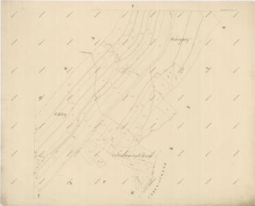
Indikační skica mapy stabilního katastru pro obec Morašice a osady Nová Sídla a Malé Sedliště (Sedlíšťka) VII; VIII
1 : 2880
Indikační skica mapy stabilního katastru pro obec Vidlatá Seč I
1 : 2880
Katastrální mapa obce Dolní Újezd a osad Václavky a Jiříkov 1
1 : 2880
Moraschitz (Morassice) - c4831-1-002 - Kaiserpflichtexemplar der Landkarten des stabilen Katasters
1 : 2880
Moraschitz (Morassice) - c4831-1-005 - Kaiserpflichtexemplar der Landkarten des stabilen Katasters
1 : 2880
Moraschitz (Morassice) - c4831-1-003 - Kaiserpflichtexemplar der Landkarten des stabilen Katasters
1 : 2880
Moraschitz (Morassice) - c4831-1-004 - Kaiserpflichtexemplar der Landkarten des stabilen Katasters
1 : 2880
Moraschitz (Morassice) - c4831-1-001 - Kaiserpflichtexemplar der Landkarten des stabilen Katasters
1 : 2880
Rzikowitz - c6720-1-003 - Kaiserpflichtexemplar der Landkarten des stabilen Katasters
1 : 2880
Rzikowitz - c6720-1-002 - Kaiserpflichtexemplar der Landkarten des stabilen Katasters
1 : 2880
Rzikowitz - c6720-1-001 - Kaiserpflichtexemplar der Landkarten des stabilen Katasters
1 : 2880
Setsch (Secz) - c8567-1-004 - Kaiserpflichtexemplar der Landkarten des stabilen Katasters
1 : 2880
Setsch (Secz) - c8567-1-002 - Kaiserpflichtexemplar der Landkarten des stabilen Katasters
1 : 2880
Setsch (Secz) - c8567-1-001 - Kaiserpflichtexemplar der Landkarten des stabilen Katasters
1 : 2880
Setsch (Secz) - c8567-1-003 - Kaiserpflichtexemplar der Landkarten des stabilen Katasters
1 : 2880
Indikační skica mapy stabilního katastru pro obec Dolní Újezd a osady Jiříkov a Václavky II; XII
1 : 2880
Katastrální mapa obce Morašice VI
1 : 2880
Mapa kostelního lesa v Dolním Újezdě
1 : 5760
Indikační skica mapy stabilního katastru pro obec Morašice a osady Nová Sídla a Malé Sedliště (Sedlíšťka) 6
1 : 2880
Indikační skica mapy stabilního katastru pro obec Řikovice a osadu Višňáry II
1 : 2880
Mapa velkostatku Litomyšl
1 : 14500
III. vojenské mapování 4056/4
1 : 25000
Gradkartenblatt
1 : 25000 Litomyšl-oblast (Česko) Hallada, Alois