Maps of Dolní Újezd
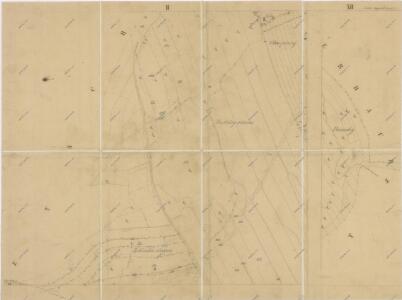
Indikační skica mapy stabilního katastru pro obec Dolní Újezd a osady Jiříkov a Václavky II; XII
1 : 2880
Mapa kostelního lesa v Dolním Újezdě
1 : 5760
Porostní mapa farního lesa v Dolním Újezdě
1 : 5760
Unter Augezd (Dolnj Augezd) - c1404-1-006 - Kaiserpflichtexemplar der Landkarten des stabilen Katasters
1 : 2880
Unter Augezd (Dolnj Augezd) - c1404-1-010 - Kaiserpflichtexemplar der Landkarten des stabilen Katasters
1 : 2880
Unter Augezd (Dolnj Augezd) - c1404-1-004 - Kaiserpflichtexemplar der Landkarten des stabilen Katasters
1 : 2880
Unter Augezd (Dolnj Augezd) - c1404-1-009 - Kaiserpflichtexemplar der Landkarten des stabilen Katasters
1 : 2880
Unter Augezd (Dolnj Augezd) - c1404-1-007 - Kaiserpflichtexemplar der Landkarten des stabilen Katasters
1 : 2880
Unter Augezd (Dolnj Augezd) - c1404-1-002 - Kaiserpflichtexemplar der Landkarten des stabilen Katasters
1 : 2880
Unter Augezd (Dolnj Augezd) - c1404-1-001 - Kaiserpflichtexemplar der Landkarten des stabilen Katasters
1 : 2880
Unter Augezd (Dolnj Augezd) - c1404-1-008 - Kaiserpflichtexemplar der Landkarten des stabilen Katasters
1 : 2880
Unter Augezd (Dolnj Augezd) - c1404-1-003 - Kaiserpflichtexemplar der Landkarten des stabilen Katasters
1 : 2880
Unter Augezd (Dolnj Augezd) - c1404-1-005 - Kaiserpflichtexemplar der Landkarten des stabilen Katasters
1 : 2880
Setsch (Secz) - c8567-1-004 - Kaiserpflichtexemplar der Landkarten des stabilen Katasters
1 : 2880
Setsch (Secz) - c8567-1-002 - Kaiserpflichtexemplar der Landkarten des stabilen Katasters
1 : 2880
Setsch (Secz) - c8567-1-001 - Kaiserpflichtexemplar der Landkarten des stabilen Katasters
1 : 2880
Setsch (Secz) - c8567-1-003 - Kaiserpflichtexemplar der Landkarten des stabilen Katasters
1 : 2880
Indikační skica mapy stabilního katastru pro obec Lažany V
1 : 2880
Katastrální mapa obce Dolní Újezd a osad Václavky a Jiříkov 3
1 : 2880
Indikační skica mapy stabilního katastru pro obec Dolní Újezd a osady Jiříkov a Václavky III
1 : 2880
Indikační skica mapy stabilního katastru pro obec Dolní Újezd a osady Jiříkov a Václavky IV
1 : 2880
Mapa velkostatku Litomyšl
1 : 14500
III. vojenské mapování 4056/4
1 : 25000
Gradkartenblatt
1 : 25000 Litomyšl-oblast (Česko) Hallada, Alois

III. vojenské mapování 4056/4
1 : 25000
Hejtmanství Lytomyšlské

Vys. Mýto
1 : 75000 Vysoké Mýto (Česko : oblast) Vojenský zeměpisný ústav
Hohenmauth und Leitomischl
1 : 75000 Litomyšl (Česko : oblast) Storch K. u. k. Militärgeographisches Institut