Maps of Otradov

Katastrální mapa pro obec Otradov
1 : 2880
Indikační skica mapy stabilního katastru pro obec Otradov
1 : 2880
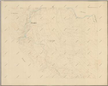
Ottradow - c5594-1-001 - Kaiserpflichtexemplar der Landkarten des stabilen Katasters
1 : 2880
Ottradow - c5594-1-003 - Kaiserpflichtexemplar der Landkarten des stabilen Katasters
1 : 2880
Ottradow - c5594-1-002 - Kaiserpflichtexemplar der Landkarten des stabilen Katasters
1 : 2880
Ottradow - c5594-1-004 - Kaiserpflichtexemplar der Landkarten des stabilen Katasters
1 : 2880
Indikační skica mapy stabilního katastru pro obec Česká Rybná
1 : 2880
Náčrt mapy pozemků dvora v Krouně
1 : 2634
Indikační skica mapy stabilního katastru pro obec Otradov adIII
1 : 2880
Mapa vsi Otradov a Miřetín
1 : 4055
Mapa vsi Rychnov
1 : 3670
Mapa vsi Krouna
1 : 3626
Krauna - c3573-1-010 - Kaiserpflichtexemplar der Landkarten des stabilen Katasters
1 : 2880
Krauna - c3573-1-006 - Kaiserpflichtexemplar der Landkarten des stabilen Katasters
1 : 2880
Krauna - c3573-1-007 - Kaiserpflichtexemplar der Landkarten des stabilen Katasters
1 : 2880
Krauna - c3573-1-008 - Kaiserpflichtexemplar der Landkarten des stabilen Katasters
1 : 2880
Krauna - c3573-1-001 - Kaiserpflichtexemplar der Landkarten des stabilen Katasters
1 : 2880
Krauna - c3573-1-002 - Kaiserpflichtexemplar der Landkarten des stabilen Katasters
1 : 2880
Krauna - c3573-1-009 - Kaiserpflichtexemplar der Landkarten des stabilen Katasters
1 : 2880
Krauna - c3573-1-005 - Kaiserpflichtexemplar der Landkarten des stabilen Katasters
1 : 2880
Krauna - c3573-1-003 - Kaiserpflichtexemplar der Landkarten des stabilen Katasters
1 : 2880
Krauna - c3573-1-004 - Kaiserpflichtexemplar der Landkarten des stabilen Katasters
1 : 2880
Böhmisch Ribna (Czeska Ribna) - c0958-1-002 - Kaiserpflichtexemplar der Landkarten des stabilen Katasters
1 : 2880
Böhmisch Ribna (Czeska Ribna) - c0958-1-003 - Kaiserpflichtexemplar der Landkarten des stabilen Katasters
1 : 2880
Böhmisch Ribna (Czeska Ribna) - c0958-1-001 - Kaiserpflichtexemplar der Landkarten des stabilen Katasters
1 : 2880
Böhmisch Ribna (Czeska Ribna) - c0958-1-004 - Kaiserpflichtexemplar der Landkarten des stabilen Katasters
1 : 2880
Mirzetin (Miřetin) - c4714-1-002 - Kaiserpflichtexemplar der Landkarten des stabilen Katasters
1 : 2880
Mirzetin (Miřetin) - c4714-1-001 - Kaiserpflichtexemplar der Landkarten des stabilen Katasters
1 : 2880
Katastrální mapa pro obec Otradov
1 : 2880