Maps of Otradov

Indikační skica mapy stabilního katastru pro obec Otradov
1 : 2880
Katastrální mapa pro obec Otradov
1 : 2880
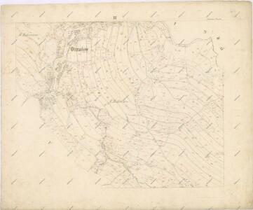
Ottradow - c5594-1-001 - Kaiserpflichtexemplar der Landkarten des stabilen Katasters
1 : 2880
Ottradow - c5594-1-003 - Kaiserpflichtexemplar der Landkarten des stabilen Katasters
1 : 2880
Ottradow - c5594-1-002 - Kaiserpflichtexemplar der Landkarten des stabilen Katasters
1 : 2880
Ottradow - c5594-1-004 - Kaiserpflichtexemplar der Landkarten des stabilen Katasters
1 : 2880
Mapa vsi Otradov a Miřetín
1 : 4055
Mapa vsi Krouna
1 : 3626
Mapa vsi Rychnov
1 : 3670
Krauna - c3573-1-010 - Kaiserpflichtexemplar der Landkarten des stabilen Katasters
1 : 2880
Krauna - c3573-1-006 - Kaiserpflichtexemplar der Landkarten des stabilen Katasters
1 : 2880
Krauna - c3573-1-007 - Kaiserpflichtexemplar der Landkarten des stabilen Katasters
1 : 2880
Krauna - c3573-1-008 - Kaiserpflichtexemplar der Landkarten des stabilen Katasters
1 : 2880
Krauna - c3573-1-001 - Kaiserpflichtexemplar der Landkarten des stabilen Katasters
1 : 2880
Krauna - c3573-1-002 - Kaiserpflichtexemplar der Landkarten des stabilen Katasters
1 : 2880
Krauna - c3573-1-009 - Kaiserpflichtexemplar der Landkarten des stabilen Katasters
1 : 2880
Krauna - c3573-1-005 - Kaiserpflichtexemplar der Landkarten des stabilen Katasters
1 : 2880
Krauna - c3573-1-003 - Kaiserpflichtexemplar der Landkarten des stabilen Katasters
1 : 2880
Krauna - c3573-1-004 - Kaiserpflichtexemplar der Landkarten des stabilen Katasters
1 : 2880
Náčrt mapy pozemků dvora v Krouně
1 : 2634
Mirzetin (Miřetin) - c4714-1-002 - Kaiserpflichtexemplar der Landkarten des stabilen Katasters
1 : 2880
Mirzetin (Miřetin) - c4714-1-001 - Kaiserpflichtexemplar der Landkarten des stabilen Katasters
1 : 2880
Indikační skica mapy stabilního katastru pro obec Česká Rybná
1 : 2880
Indikační skica mapy stabilního katastru pro obec Otradov adIII
1 : 2880
Indikační skica mapy stabilního katastru pro obec Otradov IV
1 : 2880
Přehledová mapa karlštejnských revírů
1 : 25000
Gradkartenblatt
1 : 25000 Hlinsko-oblast (Chrudim, Česko) Hallada, Alois
III. vojenské mapování 4056/3
1 : 25000
Mapa silniční sítě knížecích polesí Čachnov, Bukovina a Milovy
1 : 20000