Maps of Pardubice

Indikační skica mapy stabilního katastru pro obec Živanice V.
1 : 2880
Indikační skica mapy stabilního katastru pro město Pardubice VI.
1 : 2880
Indikační skica mapy stabilního katastru pro město Pardubice VI., ad III., ad IX.
1 : 2880
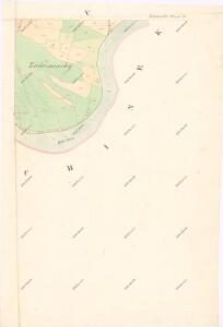
Rositz (Rosice) - c6538-1-001 - Kaiserpflichtexemplar der Landkarten des stabilen Katasters
1 : 2880
Rositz (Rosice) - c6538-1-002 - Kaiserpflichtexemplar der Landkarten des stabilen Katasters
1 : 2880
Rositz (Rosice) - c6538-1-004 - Kaiserpflichtexemplar der Landkarten des stabilen Katasters
1 : 2880
Rositz (Rosice) - c6538-1-003 - Kaiserpflichtexemplar der Landkarten des stabilen Katasters
1 : 2880
Indikační skica mapy stabilního katastru pro obec Trnová II.
1 : 2880
Pardubitz - c5633-1-006 - Kaiserpflichtexemplar der Landkarten des stabilen Katasters
1 : 2880
Pardubitz - c5633-1-007 - Kaiserpflichtexemplar der Landkarten des stabilen Katasters
1 : 2880
Pardubitz - c5633-1-003 - Kaiserpflichtexemplar der Landkarten des stabilen Katasters
1 : 2880
Pardubitz - c5633-1-009 - Kaiserpflichtexemplar der Landkarten des stabilen Katasters
1 : 2880
Pardubitz - c5633-1-011 - Kaiserpflichtexemplar der Landkarten des stabilen Katasters
1 : 2880
Pardubitz - c5633-1-005 - Kaiserpflichtexemplar der Landkarten des stabilen Katasters
1 : 2880
Pardubitz - c5633-1-002 - Kaiserpflichtexemplar der Landkarten des stabilen Katasters
1 : 2880
Pardubitz - c5633-1-004 - Kaiserpflichtexemplar der Landkarten des stabilen Katasters
1 : 2880
Pardubitz - c5633-1-001 - Kaiserpflichtexemplar der Landkarten des stabilen Katasters
1 : 2880
Pardubitz - c5633-1-010 - Kaiserpflichtexemplar der Landkarten des stabilen Katasters
1 : 2880
Pardubitz - c5633-1-008 - Kaiserpflichtexemplar der Landkarten des stabilen Katasters
1 : 2880
Mapa revíru Hrádek
1 : 5000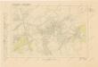
Pardubitz (Pardubice)
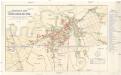
Orientační plán královského komorního města Pardubic
1 : 7400 Pardubice (Česko) Mužík, Jan Jan Liebich
Trnowa - c7978-1-002 - Kaiserpflichtexemplar der Landkarten des stabilen Katasters
1 : 2880
Trnowa - c7978-1-003 - Kaiserpflichtexemplar der Landkarten des stabilen Katasters
1 : 2880
Trnowa - c7978-1-001 - Kaiserpflichtexemplar der Landkarten des stabilen Katasters
1 : 2880
Switkow - c7651-1-001 - Kaiserpflichtexemplar der Landkarten des stabilen Katasters
1 : 2880
Switkow - c7651-1-002 - Kaiserpflichtexemplar der Landkarten des stabilen Katasters
1 : 2880
Mapa návrhu na úpravu řeky Labe u Pardubic
1 : 2880
Mapa návrhu na úpravu řeky Labe v Pardubicích
1 : 2880