Maps of Újezd u Sezemic

Indikační skica mapy stabilního katastru pro obec Újezd u Sezemic I.
1 : 2880
Indikační skica mapy stabilního katastru pro obec Borek V.
1 : 2880
Augezd - c8208-1-003 - Kaiserpflichtexemplar der Landkarten des stabilen Katasters
1 : 2880
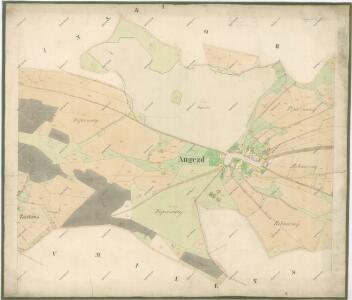
Augezd - c8208-1-001 - Kaiserpflichtexemplar der Landkarten des stabilen Katasters
1 : 2880
Augezd - c8208-1-002 - Kaiserpflichtexemplar der Landkarten des stabilen Katasters
1 : 2880
Indikační skica mapy stabilního katastru pro obec Bohumileč II.
1 : 2880
Indikační skica mapy stabilního katastru pro obec Bukovina nad Labem IV.
1 : 2880
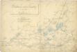
Porostní mapa obecního lesa Boreckého
1 : 2880
Indikační skica mapy stabilního katastru pro obec Dříteč I.-VI.
1 : 2880
Bohumiletsch - c0316-1-001 - Kaiserpflichtexemplar der Landkarten des stabilen Katasters
1 : 2880
Bohumiletsch - c0316-1-002 - Kaiserpflichtexemplar der Landkarten des stabilen Katasters
1 : 2880
Bohumiletsch - c0316-1-003 - Kaiserpflichtexemplar der Landkarten des stabilen Katasters
1 : 2880
Borek - c0375-1-001 - Kaiserpflichtexemplar der Landkarten des stabilen Katasters
1 : 2880
Borek - c0375-1-003 - Kaiserpflichtexemplar der Landkarten des stabilen Katasters
1 : 2880
Borek - c0375-1-002 - Kaiserpflichtexemplar der Landkarten des stabilen Katasters
1 : 2880
Bukowina - c0671-1-003 - Kaiserpflichtexemplar der Landkarten des stabilen Katasters
1 : 2880
Bukowina - c0671-1-001 - Kaiserpflichtexemplar der Landkarten des stabilen Katasters
1 : 2880
Bukowina - c0671-1-002 - Kaiserpflichtexemplar der Landkarten des stabilen Katasters
1 : 2880
Indikační skica mapy stabilního katastru pro obec Bohumileč I.
1 : 2880
III. vojenské mapování 3956/3
1 : 25000
III. vojenské mapování 3956/3
1 : 25000
Uibersichtskarte der Daschitzer Domänenforste 1871
Dašice-oblast (Česko) Le-Monnier, Franz von Šafařík, Pavel Josef Verlag des böhm. Forst Vereins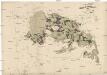
Uibersichtskarte der Daschitzer Domänenforste 1871
Dašice-oblast (Česko) Le-Monnier, Franz von Šafařík, Pavel Josef
Některé vodní stavby z 15. a 16. století na Pardubicku

Domäne Daschitz
1 : 57600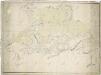
Mapa tzv. Horních revírů (albrechtický, bělečský, holický, hrádecký, chvojenecký a vysocký)
1 : 13500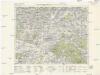
Königgrätz u. Umgebung
1 : 75000 Hradec Králové (Česko : oblast) Landesvermessungsamt Böhmen u. Mähren
Hradec Králové a okolí
1 : 75000 Hradec Králové (Česko : oblast) Vojenský zeměpisný ústav