Maps of Srch

Indikační skica mapy stabilního katastru pro obec Srch II.
1 : 2880
Indikační skica mapy stabilního katastru pro obec Pohránov I.-II.
1 : 2880
Pohranow - c5958-1-002 - Kaiserpflichtexemplar der Landkarten des stabilen Katasters
1 : 2880
Pohranow - c5958-1-001 - Kaiserpflichtexemplar der Landkarten des stabilen Katasters
1 : 2880
Indikační skica mapy stabilního katastru pro obec Pohránov II.
1 : 2880

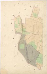
Indikační skica mapy stabilního katastru pro obec Srch I.-III.
1 : 2880
Srch - c7204-1-003 - Kaiserpflichtexemplar der Landkarten des stabilen Katasters
1 : 2880
Srch - c7204-1-002 - Kaiserpflichtexemplar der Landkarten des stabilen Katasters
1 : 2880
Srch - c7204-1-001 - Kaiserpflichtexemplar der Landkarten des stabilen Katasters
1 : 2880
Mapa lesa Obora u Stéblové
1 : 2880
Indikační skica mapy stabilního katastru pro obec Stéblová V.
1 : 2880
Obora Týniště a Oplatil u Stéblové
1 : 2880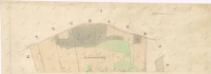
Indikační skica mapy stabilního katastru pro obec Pohránov I.
1 : 2880
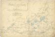
Mapa rybníka Jezero a jeho severního okolí
1 : 10000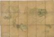
Porostní mapa revíru Stéblová
1 : 10000
Porostní mapa revíru Stéblové
1 : 10000
Mapa polesí Stéblová
1 : 15000
III. vojenské mapování 3955/4
1 : 25000
III. vojenské mapování 3955/4
1 : 25000
III. vojenské mapování 3955/4
1 : 25000
Gradkartenblatt
1 : 25000 Pardubice-oblast (Česko) Hallada, Alois
Některé vodní stavby z 15. a 16. století na Pardubicku

Domäne Daschitz
1 : 57600
Pardubice
1 : 75000 Hradec Králové (Česko : oblast) Vojenský zeměpisný ústav
III. vojenské mapování 3955
1 : 75000
Pardubice a okolí
1 : 75000 Pardubice (Česko : oblast) Vojenský zeměpisný ústav
Königgratz, Elbeteinitz und Pardubitz
1 : 75000 Hradec Králové (Česko : oblast) Fenzl K. u. k. militär-geographisches Institut
Königgratz, Elbeteinitz und Pardubitz
1 : 75000 Hradec Králové (Česko : oblast) Fenzl K. u. k. Militärgeographisches Institut