Maps of Neratov
Indikační skica mapy stabilního katastru pro obec Neratov a osady Dědek a Novinsko IV.
1 : 2880
Nerad - c5050-1-002 - Kaiserpflichtexemplar der Landkarten des stabilen Katasters
1 : 2880
Nerad - c5050-1-001 - Kaiserpflichtexemplar der Landkarten des stabilen Katasters
1 : 2880
Indikační skica mapy stabilního katastru pro obec Živanice I.
1 : 2880
Neratow - c5051-1-002 - Kaiserpflichtexemplar der Landkarten des stabilen Katasters
1 : 2880
Neratow - c5051-1-001 - Kaiserpflichtexemplar der Landkarten des stabilen Katasters
1 : 2880
Neratow - c5051-1-003 - Kaiserpflichtexemplar der Landkarten des stabilen Katasters
1 : 2880
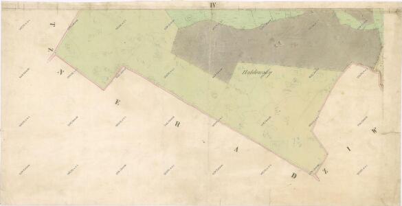
Indikační skica mapy stabilního katastru pro obec Neratov a osady Dědek a Novinsko I.-V.
1 : 2880
Indikační skica mapy stabilního katastru pro obec Živanice I.-V.
1 : 2880
Ziwanitz - c9460-1-001 - Kaiserpflichtexemplar der Landkarten des stabilen Katasters
1 : 2880
Ziwanitz - c9460-1-003 - Kaiserpflichtexemplar der Landkarten des stabilen Katasters
1 : 2880
Ziwanitz - c9460-1-004 - Kaiserpflichtexemplar der Landkarten des stabilen Katasters
1 : 2880
Ziwanitz - c9460-1-002 - Kaiserpflichtexemplar der Landkarten des stabilen Katasters
1 : 2880
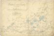
Mapa starých sádek u Bohdanče a rybník Rozhrna
1 : 2880
Těžební plán revíru Huneš
1 : 10000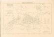
Mapa revíru Výrov
1 : 5000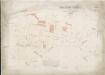
Hospodářská mapa revíru Huneš
1 : 2880
III. vojenské mapování 3955/4
1 : 25000
III. vojenské mapování 3955/4
1 : 25000
III. vojenské mapování 3955/4
1 : 25000
Gradkartenblatt
1 : 25000 Pardubice-oblast (Česko) Hallada, Alois
Některé vodní stavby z 15. a 16. století na Pardubicku

Eisenbahn Karte Wien-Dresden, Ollmütz-Trübau
1 : 72000 Blatt 10 Minarzik, Anselm J. Rauh
Pardubice
1 : 75000 Hradec Králové (Česko : oblast) Vojenský zeměpisný ústav
8. Kraj Pardubický

Chrudim a okolí
1 : 75000 Chrudim (Česko : oblast) Vojenský zeměpisný ústav
III. vojenské mapování 3955
1 : 75000
Pardubice a okolí
1 : 75000 Pardubice (Česko : oblast) Vojenský zeměpisný ústav
Königgratz, Elbeteinitz und Pardubitz
1 : 75000 Hradec Králové (Česko : oblast) Fenzl K. u. k. militär-geographisches Institut
Königgratz, Elbeteinitz und Pardubitz
1 : 75000 Hradec Králové (Česko : oblast) Fenzl K. u. k. Militärgeographisches Institut