Maps of Moravany

Indikační skica mapy stabilního katastru pro obec Moravany IV.
1 : 2880
Indikační skica mapy stabilního katastru pro obec Bělešovice I.
1 : 2880
Slepotitz (Slepotice) - c7038-1-003 - Kaiserpflichtexemplar der Landkarten des stabilen Katasters
1 : 2880
Slepotitz (Slepotice) - c7038-1-001 - Kaiserpflichtexemplar der Landkarten des stabilen Katasters
1 : 2880
Slepotitz (Slepotice) - c7038-1-002 - Kaiserpflichtexemplar der Landkarten des stabilen Katasters
1 : 2880
Indikační skica mapy stabilního katastru pro obec Platěnice IV.
1 : 2880
Beleschowitz - c0197-1-001 - Kaiserpflichtexemplar der Landkarten des stabilen Katasters
1 : 2880
Indikační skica mapy stabilního katastru pro obec Slepotice I.-III.
1 : 2880
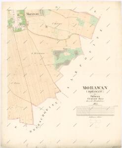
Morawan (Morawany) - c4834-1-004 - Kaiserpflichtexemplar der Landkarten des stabilen Katasters
1 : 2880
Morawan (Morawany) - c4834-1-001 - Kaiserpflichtexemplar der Landkarten des stabilen Katasters
1 : 2880
Morawan (Morawany) - c4834-1-002 - Kaiserpflichtexemplar der Landkarten des stabilen Katasters
1 : 2880
Morawan (Morawany) - c4834-1-003 - Kaiserpflichtexemplar der Landkarten des stabilen Katasters
1 : 2880
Platenitz (Platenice) - c5818-1-003 - Kaiserpflichtexemplar der Landkarten des stabilen Katasters
1 : 2880
Platenitz (Platenice) - c5818-1-002 - Kaiserpflichtexemplar der Landkarten des stabilen Katasters
1 : 2880
Platenitz (Platenice) - c5818-1-001 - Kaiserpflichtexemplar der Landkarten des stabilen Katasters
1 : 2880
Indikační skica mapy stabilního katastru pro obec Slepotice III.
1 : 2880
Mapa politického okresu Pardubického


Eisenbahn Karte Wien-Dresden, Ollmütz-Trübau
1 : 72000 Blatt 10 Minarzik, Anselm J. Rauh
8. Kraj Pardubický

Chrudim a okolí
1 : 75000 Chrudim (Česko : oblast) Vojenský zeměpisný ústav
Mapa horo- a vodopisná okresu chrudimského a nasavrckého
1 : 100000 Chrudim-oblast (Česko) Homolka, Josef Výbor ku popisu okresu chrudimského a nasavrckého
Pardubice a okolí
1 : 75000 Pardubice (Česko : oblast) Vojenský zeměpisný ústav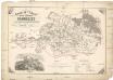
General-Karte der k. k. Reichsdomaine Pardubitz
1 : 96000 Pardubice-oblast (Česko) Urban, Joseph Jelínek, J.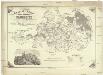
General-Karte der k. k. Reichsdomaine Pardubitz
1 : 96000 Pardubice-oblast (Česko) Urban, Joseph Jelínek, J.
Podrobná mapa Království českého
1 : 100000 Rychnov nad Kněžnou (Česko : oblast) Srp, Jan Jaroslav Bursík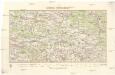
Okres Pardubice
1 : 100000 Pardubice (Česko : okres : 1960-) Kratochvíl, M. Josef Richard Vilímek
Politický okres Chrudim
1 : 100000 Chrudim-oblast (Česko) Josef Richard Vilímek