Maps of Libišany

Indikační skica mapy stabilního katastru pro obec Libišany V.
1 : 2880
Indikační skica mapy stabilního katastru pro obec Čeperka I.
1 : 2880
Indikační skica mapy stabilního katastru pro obec Opatovice II.
1 : 2880
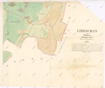
Libischan - c4017-1-001 - Kaiserpflichtexemplar der Landkarten des stabilen Katasters
1 : 2880
Libischan - c4017-1-003 - Kaiserpflichtexemplar der Landkarten des stabilen Katasters
1 : 2880
Libischan - c4017-1-004 - Kaiserpflichtexemplar der Landkarten des stabilen Katasters
1 : 2880
Libischan - c4017-1-002 - Kaiserpflichtexemplar der Landkarten des stabilen Katasters
1 : 2880
Porostní mapa revíru Čeperka stav z počátku roku 1897
1 : 10000
Porostní mapa revíru Čeperka stav z počátku roku 1897
1 : 10000
Porostní mapa revíru Čeperka stav z počátku roku 1897
1 : 10000
Porostní mapa revíru Čeperka stav z počátku roku 1897
1 : 10000
Mapa Opatovického revíru
1 : 9372
Indikační skica mapy stabilního katastru pro obec Pohřebačka I.-V.
1 : 2880
Hospodářská mapa lesa Kulhánov 1917-1926
1 : 2880
Hospodářská mapa revíru Čeperka, les Kulhánov
1 : 5000
Mapa pozemků bývalého rybníka Velká Čeperka III.
1 : 2880
Geometrický plán části lesa Kulhánov u Čeperky
1 : 2880
Porostní mapa revíru Opatovice Sekce I.
1 : 3000
Indikační skica mapy stabilního katastru pro obec Pohřebačka III.
1 : 2880
Hospodářská mapa revíru Čeperka II., Kulhánov
1 : 2880
Indikační skica mapy stabilního katastru pro obec Libišany IV.
1 : 2880
Indikační skica mapy stabilního katastru pro obec Libišany I.-V.
1 : 2880

III. vojenské mapování 3955/2
1 : 25000
III. vojenské mapování 3955/2
1 : 25000
Gradkartenblatt
1 : 25000 Hradec Králové-oblast (Česko) Hallada, Alois
Geometrische Karte von der Herrschaft Chlumetz
1 : 87000 Chlumec nad Cidlinou-oblast (Česko) Langweil, Antonín
Uibersichtskarte der Daschitzer Domänenforste 1871
Dašice-oblast (Česko) Le-Monnier, Franz von Šafařík, Pavel Josef Verlag des böhm. Forst Vereins
Uibersichtskarte der Daschitzer Domänenforste 1871
Dašice-oblast (Česko) Le-Monnier, Franz von Šafařík, Pavel Josef