Maps of Dříteč

Indikační skica mapy stabilního katastru pro obec Dříteč III., V.
1 : 2880
Indikační skica mapy stabilního katastru pro obec Hrobice I.
1 : 2880
Hrobitz - c2355-1-001 - Kaiserpflichtexemplar der Landkarten des stabilen Katasters
1 : 2880
Hrobitz - c2355-1-002 - Kaiserpflichtexemplar der Landkarten des stabilen Katasters
1 : 2880
Indikační skica mapy stabilního katastru pro obec Dříteč I.-VI.
1 : 2880
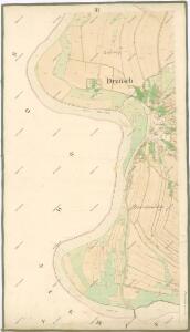
Drzitsch - c1573-1-004 - Kaiserpflichtexemplar der Landkarten des stabilen Katasters
1 : 2880
Drzitsch - c1573-1-001 - Kaiserpflichtexemplar der Landkarten des stabilen Katasters
1 : 2880
Drzitsch - c1573-1-002 - Kaiserpflichtexemplar der Landkarten des stabilen Katasters
1 : 2880
Drzitsch - c1573-1-003 - Kaiserpflichtexemplar der Landkarten des stabilen Katasters
1 : 2880
Niemtschitz - c5126-1-002 - Kaiserpflichtexemplar der Landkarten des stabilen Katasters
1 : 2880
Niemtschitz - c5126-1-001 - Kaiserpflichtexemplar der Landkarten des stabilen Katasters
1 : 2880
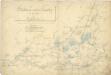
Mapa pozemků bývalého Němčického rybníka
1 : 2880
Indikační skica mapy stabilního katastru pro obec Čeperka I.-X.
1 : 2880
Indikační skica mapy stabilního katastru pro obec Libišany I.-V.
1 : 2880
III. vojenské mapování 3955/4
1 : 25000
III. vojenské mapování 3955/4
1 : 25000
III. vojenské mapování 3955/4
1 : 25000
Gradkartenblatt
1 : 25000 Pardubice-oblast (Česko) Hallada, Alois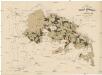
Uibersichtskarte der Daschitzer Domänenforste 1871
Dašice-oblast (Česko) Le-Monnier, Franz von Šafařík, Pavel Josef Verlag des böhm. Forst Vereins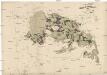
Uibersichtskarte der Daschitzer Domänenforste 1871
Dašice-oblast (Česko) Le-Monnier, Franz von Šafařík, Pavel Josef

Některé vodní stavby z 15. a 16. století na Pardubicku

Domäne Daschitz
1 : 57600
Mapa tzv. Horních revírů (albrechtický, bělečský, holický, hrádecký, chvojenecký a vysocký)
1 : 13500
Pardubice
1 : 75000 Hradec Králové (Česko : oblast) Vojenský zeměpisný ústav
III. vojenské mapování 3955
1 : 75000
Pardubice a okolí
1 : 75000 Pardubice (Česko : oblast) Vojenský zeměpisný ústav
Königgratz, Elbeteinitz und Pardubitz
1 : 75000 Hradec Králové (Česko : oblast) Fenzl K. u. k. militär-geographisches Institut
Königgratz, Elbeteinitz und Pardubitz
1 : 75000 Hradec Králové (Česko : oblast) Fenzl K. u. k. Militärgeographisches Institut