Maps of Dašice

Indikační skica mapy stabilního katastru pro městečko Dašice a osadu Velkolánské I., II.
1 : 2880
Indikační skica mapy stabilního katastru pro obec Velké Koloděje I., III.
1 : 2880
Indikační skica mapy stabilního katastru pro obec Lány u Dašic I., II.
1 : 2880
Indikační skica mapy stabilního katastru pro obec Dolní Ředice a osadu Drahoš VI., ad VII.
1 : 2880
Indikační skica mapy stabilního katastru pro městečko Dašice a osadu Velkolánské I.-VIII.
1 : 2880
Daschitz (Dasice) - c1069-1-005 - Kaiserpflichtexemplar der Landkarten des stabilen Katasters
1 : 2880
Daschitz (Dasice) - c1069-1-003 - Kaiserpflichtexemplar der Landkarten des stabilen Katasters
1 : 2880
Daschitz (Dasice) - c1069-1-006 - Kaiserpflichtexemplar der Landkarten des stabilen Katasters
1 : 2880
Daschitz (Dasice) - c1069-1-001 - Kaiserpflichtexemplar der Landkarten des stabilen Katasters
1 : 2880
Daschitz (Dasice) - c1069-1-004 - Kaiserpflichtexemplar der Landkarten des stabilen Katasters
1 : 2880
Daschitz (Dasice) - c1069-1-002 - Kaiserpflichtexemplar der Landkarten des stabilen Katasters
1 : 2880
Indikační skica mapy stabilního katastru pro obec Dolní Ředice a osadu Drahoš I.-VII.
1 : 2880
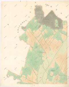
Kollodeg - c8427-1-003 - Kaiserpflichtexemplar der Landkarten des stabilen Katasters
1 : 2880
Kollodeg - c8427-1-001 - Kaiserpflichtexemplar der Landkarten des stabilen Katasters
1 : 2880
Kollodeg - c8427-1-002 - Kaiserpflichtexemplar der Landkarten des stabilen Katasters
1 : 2880
Unter Rzeditz (Dolnj Rzedicz) - c1382-1-002 - Kaiserpflichtexemplar der Landkarten des stabilen Katasters
1 : 2880
Unter Rzeditz (Dolnj Rzedicz) - c1382-1-005 - Kaiserpflichtexemplar der Landkarten des stabilen Katasters
1 : 2880
Unter Rzeditz (Dolnj Rzedicz) - c1382-1-003 - Kaiserpflichtexemplar der Landkarten des stabilen Katasters
1 : 2880
Unter Rzeditz (Dolnj Rzedicz) - c1382-1-001 - Kaiserpflichtexemplar der Landkarten des stabilen Katasters
1 : 2880
Unter Rzeditz (Dolnj Rzedicz) - c1382-1-004 - Kaiserpflichtexemplar der Landkarten des stabilen Katasters
1 : 2880
Unter Rzeditz (Dolnj Rzedicz) - c1382-1-006 - Kaiserpflichtexemplar der Landkarten des stabilen Katasters
1 : 2880
Laan (Lany) - c3805-1-002 - Kaiserpflichtexemplar der Landkarten des stabilen Katasters
1 : 2880
Laan (Lany) - c3805-1-003 - Kaiserpflichtexemplar der Landkarten des stabilen Katasters
1 : 2880
Laan (Lany) - c3805-1-001 - Kaiserpflichtexemplar der Landkarten des stabilen Katasters
1 : 2880
Czas - c0807-1-002 - Kaiserpflichtexemplar der Landkarten des stabilen Katasters
1 : 2880
Czas - c0807-1-001 - Kaiserpflichtexemplar der Landkarten des stabilen Katasters
1 : 2880
Indikační skica mapy stabilního katastru pro obec Lány u Dašic I.-IV.
1 : 2880
Mapa politického okresu Pardubického

Gradkartenblatt
1 : 25000 Holice-oblast (Pardubice, Česko) Böhm, Karl