Maps of Čepí

Indikační skica mapy stabilního katastru pro obec Čepí I., ad II.
1 : 2880
Indikační skica mapy stabilního katastru pro obec Čepí I.
1 : 2880
Indikační skica mapy stabilního katastru pro obec Čepí I.-III.
1 : 2880
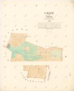
Czepě - c0852-1-001 - Kaiserpflichtexemplar der Landkarten des stabilen Katasters
1 : 2880
Czepě - c0852-1-002 - Kaiserpflichtexemplar der Landkarten des stabilen Katasters
1 : 2880
Duban - c1580-1-001 - Kaiserpflichtexemplar der Landkarten des stabilen Katasters
1 : 2880
Mateřow - c7304-1-002 - Kaiserpflichtexemplar der Landkarten des stabilen Katasters
1 : 2880
Mateřow - c7304-1-001 - Kaiserpflichtexemplar der Landkarten des stabilen Katasters
1 : 2880
Gezborzitz - c2877-1-001 - Kaiserpflichtexemplar der Landkarten des stabilen Katasters
1 : 2880
Gezborzitz - c2877-1-002 - Kaiserpflichtexemplar der Landkarten des stabilen Katasters
1 : 2880
Gezborzitz - c2877-1-003 - Kaiserpflichtexemplar der Landkarten des stabilen Katasters
1 : 2880
Waldbestandskarte des zur kais. könig. Kameralherrschaft Pardubitz gehörigen Mietitzer Reviers
1 : 3000 Pardubice-oblast (Česko) Jiřička, Josef
Mapa politického okresu Pardubického
III. vojenské mapování 4055/2
1 : 25000
III. vojenské mapování 4055/2
1 : 25000
Mapa politického okresu Pardubického...

Gradkartenblatt
1 : 25000 Chrudim-oblast (Česko) Hallada, Alois
III. vojenské mapování 4055/2
1 : 25000

Eisenbahn Karte Wien-Dresden, Ollmütz-Trübau
1 : 72000 Blatt 10 Minarzik, Anselm J. Rauh
8. Kraj Pardubický

Chrudim a okolí
1 : 75000 Chrudim (Česko : oblast) Vojenský zeměpisný ústav
III. vojenské mapování 4055
1 : 75000
Časlau und Chrudim
1 : 75000 Chrudim (Česko : oblast) Mugerauer K. u. k. militär-geographisches Institut
Časlau und Chrudim
1 : 75000 Chrudim (Česko : oblast) Mugerauer K. u. k. militär-geographisches Institut
Časlau und Chrudim
1 : 75000 Chrudim (Česko : oblast) Mugerauer K. u. k. Militärgeographisches Institut
Mapa horo- a vodopisná okresu chrudimského a nasavrckého
1 : 100000 Chrudim-oblast (Česko) Homolka, Josef Výbor ku popisu okresu chrudimského a nasavrckého
8. Kraj Pardubický

Pardubice a okolí
1 : 75000 Pardubice (Česko : oblast) Vojenský zeměpisný ústav