Maps of Hrobice

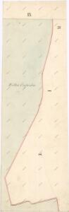
Indikační skica mapy stabilního katastru pro obec Čeperka IX.
1 : 2880
Indikační skica mapy stabilního katastru pro obec Hrobice I.
1 : 2880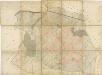
Katastrální mapa Velké Čeperky
1 : 2858
Hrobitz - c2355-1-001 - Kaiserpflichtexemplar der Landkarten des stabilen Katasters
1 : 2880
Hrobitz - c2355-1-002 - Kaiserpflichtexemplar der Landkarten des stabilen Katasters
1 : 2880
Indikační skica mapy stabilního katastru pro obec Čeperka X.
1 : 2880
Mapa rybníka Velká Čeperka s okolím
1 : 7294
Czeperka - c0851-1-002 - Kaiserpflichtexemplar der Landkarten des stabilen Katasters
1 : 2880
Czeperka - c0851-1-006 - Kaiserpflichtexemplar der Landkarten des stabilen Katasters
1 : 2880
Czeperka - c0851-1-007 - Kaiserpflichtexemplar der Landkarten des stabilen Katasters
1 : 2880
Czeperka - c0851-1-005 - Kaiserpflichtexemplar der Landkarten des stabilen Katasters
1 : 2880
Czeperka - c0851-1-008 - Kaiserpflichtexemplar der Landkarten des stabilen Katasters
1 : 2880
Czeperka - c0851-1-001 - Kaiserpflichtexemplar der Landkarten des stabilen Katasters
1 : 2880
Czeperka - c0851-1-004 - Kaiserpflichtexemplar der Landkarten des stabilen Katasters
1 : 2880
Czeperka - c0851-1-003 - Kaiserpflichtexemplar der Landkarten des stabilen Katasters
1 : 2880
Indikační skica mapy stabilního katastru pro obec Dříteč I.-VI.
1 : 2880
Indikační skica mapy stabilního katastru pro obec Čeperka I.-X.
1 : 2880
Mapa rybníka Jezero a jeho severního okolí
1 : 10000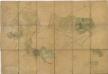
Porostní mapa revíru Stéblová
1 : 10000
Porostní mapa revíru Stéblové
1 : 10000
Mapa polesí Stéblová
1 : 15000
Indikační skica mapy stabilního katastru pro obec Libišany I.-V.
1 : 2880
III. vojenské mapování 3955/4
1 : 25000
III. vojenské mapování 3955/4
1 : 25000
III. vojenské mapování 3955/4
1 : 25000
Gradkartenblatt
1 : 25000 Pardubice-oblast (Česko) Hallada, Alois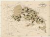
Uibersichtskarte der Daschitzer Domänenforste 1871
Dašice-oblast (Česko) Le-Monnier, Franz von Šafařík, Pavel Josef Verlag des böhm. Forst Vereins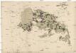
Uibersichtskarte der Daschitzer Domänenforste 1871
Dašice-oblast (Česko) Le-Monnier, Franz von Šafařík, Pavel Josef