Maps of Kopidlno

Přehledná mapa velkostatku Jičíněves - Kopidlno
1 : 23040
Přehlední mapa panství Ervína hraběte Schlika dle stavu v roce 1902
1 : 40320 Jičín-oblast (Česko) Brož, Jaroslav
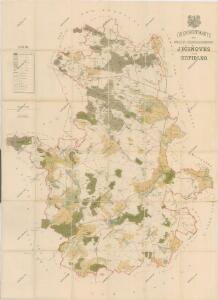
Geognostická mapa panství Ervína hraběte Schlika.
Kopidlno-oblast (Česko) Pavlík Khün
Přehledová mapa velkostatku Kopidlno - Staré Hrady
1 : 23040

III. vojenské mapování 3854/2
1 : 25000
Gradkartenblatt
1 : 25000 Jičín-oblast (Česko) Bellschan, Anton
III. vojenské mapování 3854/2
1 : 25000
III. vojenské mapování 3854/2
1 : 25000
Plan zum Treffen bei Jičin 29. Juni 1866
1 : 28880 Jičín (Česko) Ditfurth, Moritz von des K. u. k. Militärgeographischen Instituts
Plan zum Treffen bei Jičin 29. Juni 1866
1 : 28500 Jičín-oblast (Česko)
Karte der Denkmale der im Treffen bei Jičín am 29-ten Juni 1866 Gefallenen


III. vojenské mapování 3854/4
1 : 25000
III. vojenské mapování 3854/4
1 : 25000
III. vojenské mapování 3854/4
1 : 25000
Gradkartenblatt
1 : 25000 Kopidlno-oblast (Česko) Bellschan, Anton
Plan des Gefechtsfeldes von Gitschin den 29ten Juni 1866
1 : 25000 Jičín-oblast (Česko) Leithold, von Beelitz
Plan des Gefechtsfeldes von Gitschin den 29ten Juni 1866
1 : 25000 Jičín-oblast (Česko) Leithold, von Beelitz
Jitschin (Jičín)

Prachovské skály u Jičína
1 : 10000 Prachovské skály (Česko) Lepař, Zdeněk Filipovský, Karel Jan Pašek
Mapa porostů revírů Křelina, Lázně, Prachov a Střeleč
1 : 14400 Křelina (Bukvice, Jičín, Česko) Krýš, Vilém
Mapa Prachovských skal u Jičína
1 : 10000 Jičín (Česko : oblast) Klub československých turistů
Kopidlno - c3330-1-006 - Kaiserpflichtexemplar der Landkarten des stabilen Katasters
1 : 2880
Kopidlno - c3330-1-002 - Kaiserpflichtexemplar der Landkarten des stabilen Katasters
1 : 2880
Kopidlno - c3330-1-008 - Kaiserpflichtexemplar der Landkarten des stabilen Katasters
1 : 2880
Kopidlno - c3330-1-004 - Kaiserpflichtexemplar der Landkarten des stabilen Katasters
1 : 2880
Kopidlno - c3330-1-003 - Kaiserpflichtexemplar der Landkarten des stabilen Katasters
1 : 2880
Kopidlno - c3330-1-005 - Kaiserpflichtexemplar der Landkarten des stabilen Katasters
1 : 2880
Kopidlno - c3330-1-009 - Kaiserpflichtexemplar der Landkarten des stabilen Katasters
1 : 2880
Kopidlno - c3330-1-001 - Kaiserpflichtexemplar der Landkarten des stabilen Katasters
1 : 2880