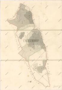
Maps of Landkreis Schwandorf

Mapa revíru Mendryka
1 : 11520
Meßtischblatt 6539 : Nabburg, 1937
1 : 250000 Nabburg. - Aufn. 1934, Ausg. 1937. - 1:25000. - München: Topograph. Zweigstelle d. Bayer. Landesvermessungsamts, 1937. - 1 Kt.
Klentsch.
from Spezialkarte der osterreichisch-ungarischen Monarchie.
Theil von Baierno
Bavorsko (Německo) im Verlage des Geogr. Instituts
Bairische Landtafeln XXIIII. Darinnē das hochlöblich Furstenthumb Obern unnd Nidern Bayrn sambt der Obern Pflaz Erz unnd Stifft Salzburg Eichstet unnd andern mehrern anstossenden Herschafftē]
1 : 145000 Mollova mapová sbírka Apian, Philipp Amman, Jost Apian, Petrus
Müllerova mapa Čech
1 : 132000
exhibet Continuationem Partis Palatinatus Super: Regiminis Straubing: et Villam Jmperialem Augusta Tiberii
1 : 150000 Mollova mapová sbírka Buna, Wilhelm C. Broenner, Heinrich Ludwig
Pars II. exhibet continuationem partis palatinatus super: regiminis Straubing: et villam jmperialem Augusta Tiberii
1 Karte : 54 x 52 cm Heinrich Ludwig Broenner
[Böhmerwald und die Umgebung von Eger]
1 : 80000 Cheb-oblast (Česko)
Fischerei-Karte des Radbusa-Gebietes
Radbuza-oblast (Česko) Schubert, Ottokar Deutsche agrarische Druckerei
Sacri Romani imperii circuli et electoratus Bavariae tabula, 2
4 Blätter : s.n.
Mappa geographica regni Bohemiae in duodecim circulos divisae ...
[Nová Mapa království Českého]
1 : 200000 Šumava Kotyška, Václav Hanf, Norbert Bursík & Kohout
Nová Mapa království Českého
1 : 200000 Šumava Kotyška, Václav Hanf, Norbert Bursík & Kohout
Deutsche Strassenprofilkarte für Radfahrer
Furth im Wald (Německo) Mittelbach's Verlag
Charte vom Klattauer Kreise ...

Taus 116, uit: Special-Karte von Mittel-Europa / nach amtlichen Quellen bearbeitet von W. Liebenow
1 : 300000 titelvariant: W. Liebenow's Mittel-Europa; Annotatie: Titel boven de bladen: W. Liebenow's Mittel-Europa Johannes Wilhelm Liebenow 1822-1897 Frankfurt a. M. : Ludwig Ravenstein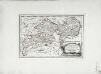
Des Herzogthums Oberpfalz nördliche Pfleggerichte mit der gefürsteten Grafschaft Sternstein
1 Karte : Kupferdruck ; 18 x 27 cm Reilly F. J. J. von Reilly

C. Flemming's Karte von Deutsch - Französischen Kriegsschaupltze

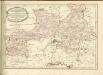
Regni Bohemiae Circuli Pilsen et Klattau Ex Müllerianis aliisque recentissimis subsidiis
Tištěná přehledná mapa Plzeňského a Klatovského kraje vydaná Homannovými dědici podle Müllerovy mapy Čech. Zachycuje sídelní a vodní síť, terén a lesy naznačeny kopečky a stromky. V sousedícím území zaznamenána významnější místa. Označena sídla významnější šlechty (hr. v. Sinzendorf v Plané, premonstráti v Teplé, benediktýní v Kladrubech, Löwenstin v Bezdružicích). Vpravo nahoře v jednoduchém rámci zdobeném vinnými úponky 'SCALA MILLIARIUM.', vpravo dole v rokajovém rámci název, vlevo dole v rokajovém rámci latinské vysvětlivky značek 'Signorum Explicatio'. Značkami rozlišeny 4 typy měst, zámky, 2 typy vsí, kláštery, samoty, mlýny a o samotě stojící kostely.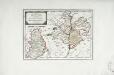
Das Fürstenthum Sulzbach und die Landgrafschaft Leuchtenberg
1 Karte : Kupferdruck ; 19 x 28 cm Reilly F. J. J. von Reilly
Sacri Imperii Romani Circuli et Electoratus Bavariae cum Finitimis Geographica Descriptio. Cum Privilegio D.D. Ordinum Generalium ut et Hollandiae West Frisiaequae]
1 : 270000 Mollova mapová sbírka Valck, Leonardus
Carte chorographique de la Boheme...

Carte topographique d'Allemagne contenant le Haut Palatinat, une partie du royaume de Boheme, de la Basse Baviere
1 Karte : Kupferdruck ; 46 x 61 cm Jaeger; Facius I. W. A. Iaeger ches qui cette carte se vend
Sacri Romani imperii circuli et electoratus Bavariae tabula, 1
4 Blätter : s.n.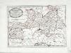
Des Herzogthums Oberpfalz südliche Pfleggerichte
1 Karte : Kupferdruck ; 24 x 35 cm Reilly F. J. J. von Reilly