Maps of okres Semily
Makulář mapy oblasti severně od Špindlerova Mlýna Sectio 14
1 : 2700
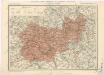
Charte vom Bidczower Kreise des Königreiches Böheim
1 : 250000 Nový Bydžov-oblast (Česko) Kreibich, František Jakub Jindřich Enders, C. W. C.W. Enders
Charte vom Bidczower Kreise des Königreiches Böheim
1 : 250000 Nový Bydžov-oblast (Česko) Kreibich, František Jakub Jindřich Enders, C. W. C.W. Enders
Charte vom Bidczower Kreise des Königreichs Böheim
1 : 250000 Nový Bydžov-oblast (Česko) Kreibich, František Jakub Jindřich Kettner, Carl C. W. Enders
Charte vom Bidczower Kreise des Königreiches Böheim
1 : 250000 Nový Bydžov-oblast (Česko) Kreibich, František Jakub Jindřich Enders, C. W. C.W. Enders
Charte vom Bidczower Kreise des Königreiches Böheim
1 : 250000 Nový Bydžov-oblast (Česko) Kreibich, František Jakub Jindřich Enders, C. W. C.W. Enders
Charte vom Bidczower Kreise des Königreiches Böheim
1 : 250000 Nový Bydžov-oblast (Česko) Kreibich, František Jakub Jindřich Enders, C. W. C.W. Enders
Charte vom Bidczower Kreise des Königreichs Böheim
1 : 250000 Nový Bydžov-oblast (Česko) Kreibich, František Jakub Jindřich Kettner, Carl C. W. Enders
Charte vom Bidczower Kreise des Königreiches Böheim
1 : 250000 Nový Bydžov-oblast (Česko) Kreibich, František Jakub Jindřich Enders, C. W. C.W. Enders
Charte vom Bidczhofer Kreise ...

Charte vom Bidczower Kreise des Königreiches Böheim

Müllerova mapa Čech
1 : 132000
Mappa geographica regni Bohemiae in duodecim circuloc divisae ... Sectio. IX.

Monumenta Cartographica Bohemiae II.: Müllerova mapa

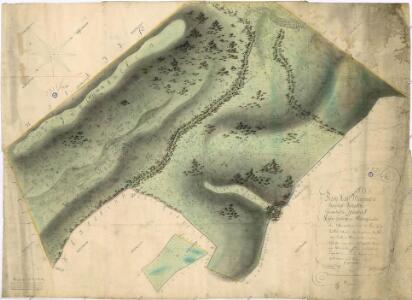
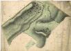
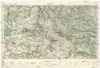
Generální mapa okresního hejtmanství Semilského
1 : 220000 Semily-oblast (Česko) Wagner, Jan Eduard F. Kytka
Mapa okresního hejtmanství Jičínského

Mapa okresního hejtmanství Jičínského
Generální mapa okresních hejtmanství
Generální mapa okresních hejtmanství

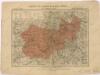
Mapa okresního hejtmanství jičínského
1 : 100000 Jičín-oblast (Česko) Erben, Josef nákladem Karla Janského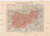
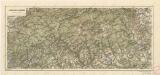
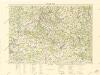
Generální mapa okresního hejtmanství Jičínského
1 : 220000 Jičín-oblast (Česko) Wagner, Jan Eduard F. Kytka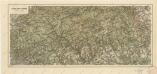
Jizerské hory a Krkonoše
Jizerské hory a Krkonoše
Český ráj
1 : 75000 Český ráj (Česko) Vojenský zeměpisný ústav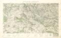
Turistická mapa Českého ráje
Český ráj

Český ráj