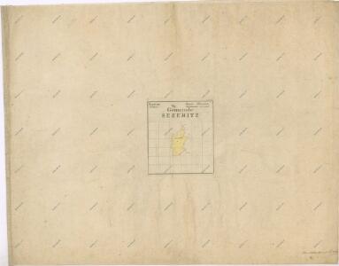
Maps of Sezemice

Indikační skica mapy stabilního katastru pro město Sezemice I.-VI.
1 : 2880
Sezemitz - c6856-1-003 - Kaiserpflichtexemplar der Landkarten des stabilen Katasters
1 : 2880
Sezemitz - c6856-1-004 - Kaiserpflichtexemplar der Landkarten des stabilen Katasters
1 : 2880
Sezemitz - c6856-1-002 - Kaiserpflichtexemplar der Landkarten des stabilen Katasters
1 : 2880
Sezemitz - c6856-1-001 - Kaiserpflichtexemplar der Landkarten des stabilen Katasters
1 : 2880
Sezemitz - c6856-1-005 - Kaiserpflichtexemplar der Landkarten des stabilen Katasters
1 : 2880
Hospodářská mapa Bělobranské dubiny
1 : 2880
Indikační skica mapy stabilního katastru pro obec Lukovna I.-II.
1 : 2880
Kollodeg - c8427-1-003 - Kaiserpflichtexemplar der Landkarten des stabilen Katasters
1 : 2880
Kollodeg - c8427-1-001 - Kaiserpflichtexemplar der Landkarten des stabilen Katasters
1 : 2880
Kollodeg - c8427-1-002 - Kaiserpflichtexemplar der Landkarten des stabilen Katasters
1 : 2880
Kladina - c3105-1-001 - Kaiserpflichtexemplar der Landkarten des stabilen Katasters
1 : 2880
Kladina - c3105-1-002 - Kaiserpflichtexemplar der Landkarten des stabilen Katasters
1 : 2880
Indikační skica mapy stabilního katastru pro obec Kladina I.
1 : 2880
Porostní mapa revíru Koloděje
1 : 10000
Indikační skica mapy stabilního katastru pro město Sezemice IV.
1 : 2880
Indikační skica mapy stabilního katastru pro obec Lukovna II.
1 : 2880
Indikační skica mapy stabilního katastru pro město Sezemice II.
1 : 2880
Indikační skica mapy stabilního katastru pro obec Počaply I.-II.
1 : 2880
Porostní mapa revír Hůrka a Koloděje
1 : 10000
Indikační skica mapy stabilního katastru pro obec Choteč III.
1 : 2880
Hospodářská mapa revíru Koloděje
1 : 2880
Indikační skica mapy stabilního katastru pro město Sezemice III.
1 : 2880
Podczapel - c5865-1-001 - Kaiserpflichtexemplar der Landkarten des stabilen Katasters
1 : 2880
Podczapel - c5865-1-002 - Kaiserpflichtexemplar der Landkarten des stabilen Katasters
1 : 2880
Hospodářská mapa revíru Koloděje
1 : 2880
Porostní mapa revíru Koloděje Sekce I.
1 : 2880
Lukowna - c4316-1-002 - Kaiserpflichtexemplar der Landkarten des stabilen Katasters
1 : 2880
Lukowna - c4316-1-001 - Kaiserpflichtexemplar der Landkarten des stabilen Katasters
1 : 2880