Maps of Čeperka

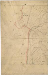
Mapa pozemků bývalého rybníka Velká Čeperka III.
1 : 2880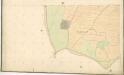
Indikační skica mapy stabilního katastru pro obec Opatovice IV.
1 : 2880
Indikační skica mapy stabilního katastru pro obec Opatovice II.
1 : 2880
Geometrický plán části lesa Kulhánov u Čeperky
1 : 2880
Hospodářská mapa lesa Kulhánov 1917-1926
1 : 2880
Hospodářská mapa revíru Čeperka II., Kulhánov
1 : 2880
Hospodářská mapa revíru Čeperka, les Kulhánov
1 : 5000
Porostní mapa revíru Opatovice Sekce I.
1 : 3000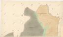
Indikační skica mapy stabilního katastru pro obec Čeperka I.
1 : 2880
Indikační skica mapy stabilního katastru pro obec Libišany V.
1 : 2880
Porostní mapa revíru Čeperka stav z počátku roku 1897
1 : 10000
Porostní mapa revíru Čeperka stav z počátku roku 1897
1 : 10000
Porostní mapa revíru Čeperka stav z počátku roku 1897
1 : 10000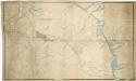
Koncept mapy revíru Opatovice
1 : 2600
Porostní mapa revíru Čeperka stav z počátku roku 1897
1 : 10000
Czeperka - c0851-1-002 - Kaiserpflichtexemplar der Landkarten des stabilen Katasters
1 : 2880
Czeperka - c0851-1-006 - Kaiserpflichtexemplar der Landkarten des stabilen Katasters
1 : 2880
Czeperka - c0851-1-007 - Kaiserpflichtexemplar der Landkarten des stabilen Katasters
1 : 2880
Czeperka - c0851-1-005 - Kaiserpflichtexemplar der Landkarten des stabilen Katasters
1 : 2880
Czeperka - c0851-1-008 - Kaiserpflichtexemplar der Landkarten des stabilen Katasters
1 : 2880
Czeperka - c0851-1-001 - Kaiserpflichtexemplar der Landkarten des stabilen Katasters
1 : 2880
Czeperka - c0851-1-004 - Kaiserpflichtexemplar der Landkarten des stabilen Katasters
1 : 2880
Czeperka - c0851-1-003 - Kaiserpflichtexemplar der Landkarten des stabilen Katasters
1 : 2880
Porostní mapa revíru Čeperka 1917-1926
1 : 5000
Mapa Opatovického revíru
1 : 9372
Mapa dřevin obce Čeperka
1 : 5000
Mapa probírek a čistících sečí obce Čeperka
1 : 5000
Opatowitz - c5491-1-001 - Kaiserpflichtexemplar der Landkarten des stabilen Katasters
1 : 2880
Opatowitz - c5491-1-004 - Kaiserpflichtexemplar der Landkarten des stabilen Katasters
1 : 2880
Opatowitz - c5491-1-002 - Kaiserpflichtexemplar der Landkarten des stabilen Katasters
1 : 2880
Opatowitz - c5491-1-005 - Kaiserpflichtexemplar der Landkarten des stabilen Katasters
1 : 2880