Maps of Čeperka

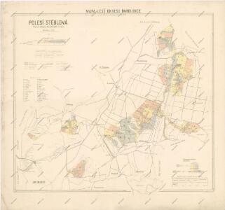
Mapa polesí Stéblová
1 : 15000
Porostní mapa revíru Stéblové
1 : 10000
Porostní mapa revíru Stéblová
1 : 10000
Mapa rybníka Jezero a jeho severního okolí
1 : 10000
Czeperka - c0851-1-002 - Kaiserpflichtexemplar der Landkarten des stabilen Katasters
1 : 2880
Czeperka - c0851-1-006 - Kaiserpflichtexemplar der Landkarten des stabilen Katasters
1 : 2880
Czeperka - c0851-1-007 - Kaiserpflichtexemplar der Landkarten des stabilen Katasters
1 : 2880
Czeperka - c0851-1-005 - Kaiserpflichtexemplar der Landkarten des stabilen Katasters
1 : 2880
Czeperka - c0851-1-008 - Kaiserpflichtexemplar der Landkarten des stabilen Katasters
1 : 2880
Czeperka - c0851-1-001 - Kaiserpflichtexemplar der Landkarten des stabilen Katasters
1 : 2880
Czeperka - c0851-1-004 - Kaiserpflichtexemplar der Landkarten des stabilen Katasters
1 : 2880
Czeperka - c0851-1-003 - Kaiserpflichtexemplar der Landkarten des stabilen Katasters
1 : 2880
Indikační skica mapy stabilního katastru pro obec Čeperka I.-X.
1 : 2880
Koncept mapy revíru Opatovice
1 : 2600
Mapa rybníka Velká Čeperka s okolím
1 : 7294
Mapa polesí Stéblová
1 : 5000
Mapa Opatovického revíru
1 : 9372
Porostní mapa revíru Čeperka stav z počátku roku 1897
1 : 10000
Mapa lesa Obora u Stéblové
1 : 2880
Indikační skica mapy stabilního katastru pro obec Staré Ždánice a osadu Nové Ždánice I.-V.
1 : 2880
Porostní mapa revíru Čeperka stav z počátku roku 1897
1 : 10000
Porostní mapa revíru Čeperka 1917-1926
1 : 5000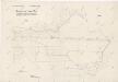
Geometrický plán Velké a Malé Čeperky
1 : 2880
Mapa dřevin obce Čeperka
1 : 5000
Steblowa - c7325-1-004 - Kaiserpflichtexemplar der Landkarten des stabilen Katasters
1 : 2880
Steblowa - c7325-1-001 - Kaiserpflichtexemplar der Landkarten des stabilen Katasters
1 : 2880
Steblowa - c7325-1-002 - Kaiserpflichtexemplar der Landkarten des stabilen Katasters
1 : 2880
Steblowa - c7325-1-003 - Kaiserpflichtexemplar der Landkarten des stabilen Katasters
1 : 2880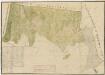
Mapa revíru Hrádek
1 : 2600
Dollan - c1239-1-004 - Kaiserpflichtexemplar der Landkarten des stabilen Katasters
1 : 2880
Dollan - c1239-1-003 - Kaiserpflichtexemplar der Landkarten des stabilen Katasters
1 : 2880
Dollan - c1239-1-002 - Kaiserpflichtexemplar der Landkarten des stabilen Katasters
1 : 2880