Maps of Ráby

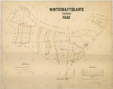
Hospodářská mapa revíru Ráby
1 : 5000
Mapa hájemství Ráby
1 : 5000
Porostní mapa hájemství Ráby
1 : 10000
Brožan - c0533-1-002 - Kaiserpflichtexemplar der Landkarten des stabilen Katasters
1 : 2880
Brožan - c0533-1-001 - Kaiserpflichtexemplar der Landkarten des stabilen Katasters
1 : 2880
Brožan - c0533-1-003 - Kaiserpflichtexemplar der Landkarten des stabilen Katasters
1 : 2880
Mapa probírek hájemství Ráby
1 : 5000
Raab - c6301-1-002 - Kaiserpflichtexemplar der Landkarten des stabilen Katasters
1 : 2880
Raab - c6301-1-001 - Kaiserpflichtexemplar der Landkarten des stabilen Katasters
1 : 2880
Niemtschitz - c5126-1-002 - Kaiserpflichtexemplar der Landkarten des stabilen Katasters
1 : 2880
Niemtschitz - c5126-1-001 - Kaiserpflichtexemplar der Landkarten des stabilen Katasters
1 : 2880
Mapa pozemků bývalého Němčického rybníka
1 : 2880
Porostní mapa hájemství Ráby
1 : 10000
Indikační skica mapy stabilního katastru pro obec Srch I.-III.
1 : 2880
Srch - c7204-1-003 - Kaiserpflichtexemplar der Landkarten des stabilen Katasters
1 : 2880
Srch - c7204-1-002 - Kaiserpflichtexemplar der Landkarten des stabilen Katasters
1 : 2880
Srch - c7204-1-001 - Kaiserpflichtexemplar der Landkarten des stabilen Katasters
1 : 2880
Kunetitz - c3707-1-003 - Kaiserpflichtexemplar der Landkarten des stabilen Katasters
1 : 2880
Kunetitz - c3707-1-002 - Kaiserpflichtexemplar der Landkarten des stabilen Katasters
1 : 2880
Kunetitz - c3707-1-001 - Kaiserpflichtexemplar der Landkarten des stabilen Katasters
1 : 2880
Indikační skica mapy stabilního katastru pro obec Srch III.
1 : 2880
Indikační skica mapy stabilního katastru pro obec Staré a Nové Hradiště a Cihelnu I.
1 : 2880
Indikační skica mapy stabilního katastru pro obec Staré a Nové Hradiště a Cihelnu III.
1 : 2880
Indikační skica mapy stabilního katastru pro obec Ráby IV.
1 : 2880
Mapa rybníka Baroch
1 : 2000
Indikační skica mapy stabilního katastru pro obec Čeperka X.
1 : 2880
Mapa rybníka Jezero a jeho severního okolí
1 : 10000
Indikační skica mapy stabilního katastru pro obec Dříteč I.-VI.
1 : 2880
Indikační skica mapy stabilního katastru pro obec Čeperka I.-X.
1 : 2880