Maps of Dvory
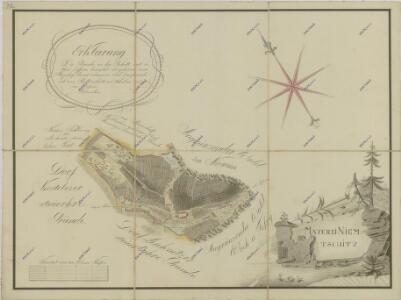
Mapa pozemků dvora Němčice 1

Dwur (Dwori) - c1633-1-001 - Kaiserpflichtexemplar der Landkarten des stabilen Katasters
1 : 2880
Zabrdy - c9017-1-003 - Kaiserpflichtexemplar der Landkarten des stabilen Katasters
1 : 2880
Zabrdy - c9017-1-002 - Kaiserpflichtexemplar der Landkarten des stabilen Katasters
1 : 2880
Zabrdy - c9017-1-001 - Kaiserpflichtexemplar der Landkarten des stabilen Katasters
1 : 2880
Laschitz (Lazisste) - c3832-1-003 - Kaiserpflichtexemplar der Landkarten des stabilen Katasters
1 : 2880
Laschitz (Lazisste) - c3832-1-002 - Kaiserpflichtexemplar der Landkarten des stabilen Katasters
1 : 2880
Laschitz (Lazisste) - c3832-1-001 - Kaiserpflichtexemplar der Landkarten des stabilen Katasters
1 : 2880
Wossek - c5531-1-005 - Kaiserpflichtexemplar der Landkarten des stabilen Katasters
1 : 2880
Wossek - c5531-1-004 - Kaiserpflichtexemplar der Landkarten des stabilen Katasters
1 : 2880
Wossek - c5531-1-003 - Kaiserpflichtexemplar der Landkarten des stabilen Katasters
1 : 2880
Wossek - c5531-1-007 - Kaiserpflichtexemplar der Landkarten des stabilen Katasters
1 : 2880
Wossek - c5531-1-006 - Kaiserpflichtexemplar der Landkarten des stabilen Katasters
1 : 2880
Wossek - c5531-1-002 - Kaiserpflichtexemplar der Landkarten des stabilen Katasters
1 : 2880
Wossek - c5531-1-001 - Kaiserpflichtexemplar der Landkarten des stabilen Katasters
1 : 2880
Horauth - c2189-1-001 - Kaiserpflichtexemplar der Landkarten des stabilen Katasters
1 : 2880
Horauth - c2189-1-002 - Kaiserpflichtexemplar der Landkarten des stabilen Katasters
1 : 2880
Mapka okolí Husince
Tschechische Republik Böhmen Husinec Hus, Jan
III. vojenské mapování 4352/3
1 : 25000
Gradkartenblatt
1 : 25000 Prachatice-oblast (Česko) Albrecht, Julius
[Kartenblatt]
1 : 25000 Prachatice (Česko : oblast) Reichsamt für Landesaufnahme
[Gradkartenblatt]
1 : 25000 Prachatice-oblast (Česko)


Prachatice a okolí
1 : 75000 Prachatice (Česko : oblast) Vojenský zeměpisný ústav
Prachatice
1 : 75000 Prachatice (Česko : oblast) Vojenský zeměpisný ústav
Übersichtskarte der Herrschaft Winterberg
1 : 94800 Vimperk-oblast (Česko) Verlag des böhm. Forstverein's
Mapy plánování ČSR

III. vojenské mapování 4352
1 : 75000