Maps of Smržov u Lomnice nad Lužnicí

Porostní mapa polesí Dvořiště 1

Hospodářská mapa polesí Lomnice 1
1 : 5780
Hospodářská mapa polesí Lomnice 1
1 : 5780
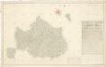
Smržov o. Jindřichův Hradec 1
1 : 2880
Mazelov o. České Budějovice 1
1 : 2380
Porostní mapa polesí Lomnice 1

Porostní mapa polesí Dvořiště 1
1 : 10000
Smrzow - c7096-1-004 - Kaiserpflichtexemplar der Landkarten des stabilen Katasters
1 : 2880
Smrzow - c7096-1-005 - Kaiserpflichtexemplar der Landkarten des stabilen Katasters
1 : 2880
Smrzow - c7096-1-002 - Kaiserpflichtexemplar der Landkarten des stabilen Katasters
1 : 2880
Smrzow - c7096-1-007 - Kaiserpflichtexemplar der Landkarten des stabilen Katasters
1 : 2880
Smrzow - c7096-1-001 - Kaiserpflichtexemplar der Landkarten des stabilen Katasters
1 : 2880
Smrzow - c7096-1-006 - Kaiserpflichtexemplar der Landkarten des stabilen Katasters
1 : 2880
Smrzow - c7096-1-003 - Kaiserpflichtexemplar der Landkarten des stabilen Katasters
1 : 2880
Smržov o. Jindřichův Hradec 1
1 : 2880
Administrativní mapa třeboňského panství se statky Bzí,Lomnice, Borovany,Hamr a Val 1

Přehledná mapa polesí Dvořiště 1
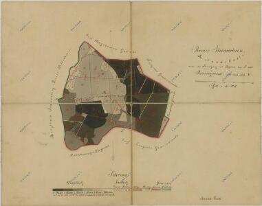
Geometrický plán lesů ve velechvínském revíru s vyznačením 110, 130, 140 a 180letého obmýtí 1
Geometrický plán velechvínského revíru 1

Generální mapa panství Třeboň a inkorporovaných statků Bzí, Lomnice, Borovany, Třeboň, Hamr a Val 1

Mazalow - c4537-1-003 - Kaiserpflichtexemplar der Landkarten des stabilen Katasters
1 : 2880
Mazalow - c4537-1-001 - Kaiserpflichtexemplar der Landkarten des stabilen Katasters
1 : 2880
Mazalow - c4537-1-004 - Kaiserpflichtexemplar der Landkarten des stabilen Katasters
1 : 2880
Mazalow - c4537-1-005 - Kaiserpflichtexemplar der Landkarten des stabilen Katasters
1 : 2880
Mazalow - c4537-1-002 - Kaiserpflichtexemplar der Landkarten des stabilen Katasters
1 : 2880
Unt. Slowenitz - c1389-1-001 - Kaiserpflichtexemplar der Landkarten des stabilen Katasters
1 : 2880
Unt. Slowenitz - c1389-1-005 - Kaiserpflichtexemplar der Landkarten des stabilen Katasters
1 : 2880
Unt. Slowenitz - c1389-1-004 - Kaiserpflichtexemplar der Landkarten des stabilen Katasters
1 : 2880
Unt. Slowenitz - c1389-1-003 - Kaiserpflichtexemplar der Landkarten des stabilen Katasters
1 : 2880
Unt. Slowenitz - c1389-1-006 - Kaiserpflichtexemplar der Landkarten des stabilen Katasters
1 : 2880