Maps of Žimutice

Porostní mapa polesí Dolejška 1
Porostní mapa polesí Bzí 1
1 : 10000
Geometrický plán lesů Paseky a Pasečka na statku Bzí 1

Geometrický plán lesů Paseky a Pasečka na statku Bzí 1
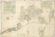
Záměrná mapa-brouillon vsi Pořežany s přilehlými pozemky

Gross Porzižan - c6027-1-003 - Kaiserpflichtexemplar der Landkarten des stabilen Katasters
1 : 2880
Gross Porzižan - c6027-1-002 - Kaiserpflichtexemplar der Landkarten des stabilen Katasters
1 : 2880
Gross Porzižan - c6027-1-005 - Kaiserpflichtexemplar der Landkarten des stabilen Katasters
1 : 2880
Gross Porzižan - c6027-1-001 - Kaiserpflichtexemplar der Landkarten des stabilen Katasters
1 : 2880
Gross Porzižan - c6027-1-004 - Kaiserpflichtexemplar der Landkarten des stabilen Katasters
1 : 2880
Hrožniowitz - c2365-1-001 - Kaiserpflichtexemplar der Landkarten des stabilen Katasters
1 : 2880
Hrožniowitz - c2365-1-002 - Kaiserpflichtexemplar der Landkarten des stabilen Katasters
1 : 2880
Hrožniowitz - c2365-1-003 - Kaiserpflichtexemplar der Landkarten des stabilen Katasters
1 : 2880
Hrožniowitz - c2365-1-004 - Kaiserpflichtexemplar der Landkarten des stabilen Katasters
1 : 2880
Porostní mapa polesí Bzí 1
1 : 15000
Mapa lesních cest v polesí Bzí 1
1 : 15000
Porostní mapa polesí Bzí 1
1 : 15000
Porostní mapa revíru Bzí pro desetiletí 1931/1940 1
1 : 15000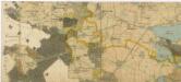
Administrativní mapa třeboňského panství se statky Bzí,Lomnice, Borovany,Hamr a Val 1
Geometrický plán vrchnostenských lesů v purkareckém a litoradlickém revíru 1

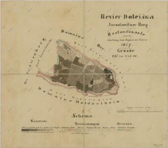
Jaroslawitz - c2775-1-006 - Kaiserpflichtexemplar der Landkarten des stabilen Katasters
1 : 2880
Jaroslawitz - c2775-1-001 - Kaiserpflichtexemplar der Landkarten des stabilen Katasters
1 : 2880
Jaroslawitz - c2775-1-007 - Kaiserpflichtexemplar der Landkarten des stabilen Katasters
1 : 2880
Jaroslawitz - c2775-1-004 - Kaiserpflichtexemplar der Landkarten des stabilen Katasters
1 : 2880
Jaroslawitz - c2775-1-005 - Kaiserpflichtexemplar der Landkarten des stabilen Katasters
1 : 2880
Jaroslawitz - c2775-1-003 - Kaiserpflichtexemplar der Landkarten des stabilen Katasters
1 : 2880
Jaroslawitz - c2775-1-002 - Kaiserpflichtexemplar der Landkarten des stabilen Katasters
1 : 2880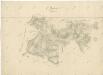
Přehledná mapa polesí Radonice 1
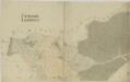
Líšnice o. České Budějovice 1
1 : 2880