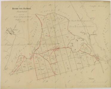
Maps of Majdalena

Porostní obrysová mapa polesí Barbora 1
1 : 10000
Mapy činžovních pozemků V. sekce třeboňského velkostatku pro obce: Cep, Hrdlořezy, Jílovice, Kramolín, Šalmanovice 1

Geometrický plán polesí Cep

Herda - c4353-2-003 - Kaiserpflichtexemplar der Landkarten des stabilen Katasters
1 : 2880
Herda - c4353-2-002 - Kaiserpflichtexemplar der Landkarten des stabilen Katasters
1 : 2880
Herda - c4353-2-008 - Kaiserpflichtexemplar der Landkarten des stabilen Katasters
1 : 2880
Herda - c4353-2-004 - Kaiserpflichtexemplar der Landkarten des stabilen Katasters
1 : 2880
Herda - c4353-2-006 - Kaiserpflichtexemplar der Landkarten des stabilen Katasters
1 : 2880
Herda - c4353-2-007 - Kaiserpflichtexemplar der Landkarten des stabilen Katasters
1 : 2880
Herda - c4353-2-005 - Kaiserpflichtexemplar der Landkarten des stabilen Katasters
1 : 2880
Herda - c4353-2-009 - Kaiserpflichtexemplar der Landkarten des stabilen Katasters
1 : 2880
Herda - c4353-2-001 - Kaiserpflichtexemplar der Landkarten des stabilen Katasters
1 : 2880
Hospodářská mapa polesí Cep 1

Geometrický plán polesí Cep
Porostní mapa polesí Cep 1

Cep o. Jindřichův Hradec 1
1 : 2880
Geometrický plán lesů u Vobůrky, Dlouhý vochoz u Březových můstků a u Černého kusu s přilehlými deputátními loukami a činžovními pozemky

Hospodářská mapa polesí Cep 1

Hospodářská mapa polesí Cep 1
Hospodářská mapa polesí Cep 1
Hospodářská mapa polesí Cep 1

Branná o. Jindřichův Hradec 1
1 : 2880
Herda o. Jindřichův Hradec 1
1 : 2880
Cep o. Jidndřichův Hradec 1
1 : 2880
Cep o. Jidndřichův Hradec 1
1 : 2880
Hospodářská mapa polesí Cep 1
1 : 5760
Hospodářská mapa polesí Cep 1
1 : 5760
Mapy činžovních pozemků III. sekce třeboňského velkostatku pro obce: Branná, Břilice, Domanín, Herda, Holičky, Kojákovice, Spolí, Třeboň 1

Mapy činžovních pozemků III. sekce třeboňského velkostatku pro obce: Břilice, Domanín, Herda, Holičky, Kojákovice, Spolí, Třeboň 1
1 : 2880