Maps of Lišov

Hospodářská mapa polesí Štěpánovice 1
1 : 5760
Lischau - c4150-1-001 - Kaiserpflichtexemplar der Landkarten des stabilen Katasters
1 : 2880
Lischau - c4150-1-008 - Kaiserpflichtexemplar der Landkarten des stabilen Katasters
1 : 2880
Lischau - c4150-1-003 - Kaiserpflichtexemplar der Landkarten des stabilen Katasters
1 : 2880
Lischau - c4150-1-006 - Kaiserpflichtexemplar der Landkarten des stabilen Katasters
1 : 2880
Lischau - c4150-1-002 - Kaiserpflichtexemplar der Landkarten des stabilen Katasters
1 : 2880
Lischau - c4150-1-005 - Kaiserpflichtexemplar der Landkarten des stabilen Katasters
1 : 2880
Lischau - c4150-1-004 - Kaiserpflichtexemplar der Landkarten des stabilen Katasters
1 : 2880
Lischau - c4150-1-007 - Kaiserpflichtexemplar der Landkarten des stabilen Katasters
1 : 2880
Lischau - c4150-1-009 - Kaiserpflichtexemplar der Landkarten des stabilen Katasters
1 : 2880
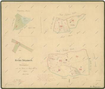
Štěpánovice o. České Budějovice 1
1 : 2880
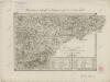
Mapy činžovních pozemků IV. sekce třeboňského velkostatku pro obce: Dolní Miletín, Doubravice, Doudleby, Hodovice, Horní Miletín, Ledenice, Nový Dvůr, Petrovice, Slavošovice, Štěpánovice, Zborov 1
Administrativní mapa třeboňského panství se statky Bzí,Lomnice, Borovany,Hamr a Val 1
Záměrná mapa hranic lesů a pozemků v okolí městečka Lišov 1
Přehledná mapa polesí Ledenice 1

Situační plán erární silnice od dvora Kuna do Ledenic 1

Topographische Karte ... Herrschaft Krummau ...

Topographische Karte der in Böhmen budweiser Kreises liegenden
II. vojenské mapování 35
1 : 144000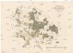
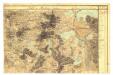
Uibersichts-Karte der hochfürstlich zu Schwarzenbergschen Domaine Frauenberg nach dem Stande im Jahre 1876
1 : 58000 Hluboká nad Vltavou-oblast (Česko) Danesch, Jos. Kreibich, František Jakub Jindřich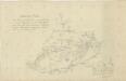
Situační plán vodní soustavy v jihozápadní části Třeboňské pánve

České Budějovice a okolí
1 : 75000 České Budějovice (Česko : oblast) Vojenský zeměpisný ústav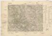
Třeboň
1 : 75000 Třeboň (Česko : oblast) Reichsamt für Landesaufnahme
Třeboň
1 : 75000 Třeboň-oblast (Česko) Vojenský zeměpisný ústav
Administrativ Karte der Hochfürstlich Schwarzenberg ́schen Herrschaft Frauenberg...

Vltava

Podrobná mapa Království českého, Markrabství moravského a Vévodství slezského
1 : 100000 Kaplice (Český Krumlov, Česko : oblast) Srp, Jan Jos. R. Vilímek
Podrobná mapa Království českého
1 : 100000 Kaplice (Český Krumlov, Česko : oblast) Srp, Jan Jaroslav Bursík