Maps of Štěpánovice
Hospodářská mapa polesí Štěpánovice 1
Mapa dělení pozemků dvora Vranín po I. pozemkové reformě, s vyznačením bonity půdy 1
1 : 5760
kopie-kopie-kopie-Mapy činžovních pozemků III. sekce třeboňského velkostatku pro obce: Břilice, Domanín, Herda, Holičky, Kojákovice, Spolí, Třeboň 1
1 : 2880
Mapy činžovních pozemků III. sekce třeboňského velkostatku pro obce: Branná, Břilice, Domanín, Herda, Holičky, Kojákovice, Spolí 1

Štěpánovice o. České Budějovice 1
1 : 2880
Manuály parcelace pozemků dvora Vranín 1
1 : 2880
Mapy činžovních pozemků III. sekce třeboňského velkostatku pro obce: Branná, Břilice, Domanín, Herda, Holičky, Kojákovice, Spolí, Třeboň 1

Libín o. České Budějovice 1
1 : 2880
Situační plány vrchnostenských objektů na velkostatku Třeboň 1
1 : 2880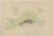
Plán borkoviště Vimberky u rybníka Svět 1

Stiepanowitz - c7778-1-008 - Kaiserpflichtexemplar der Landkarten des stabilen Katasters
1 : 2880
Stiepanowitz - c7778-1-007 - Kaiserpflichtexemplar der Landkarten des stabilen Katasters
1 : 2880
Stiepanowitz - c7778-1-002 - Kaiserpflichtexemplar der Landkarten des stabilen Katasters
1 : 2880
Stiepanowitz - c7778-1-005 - Kaiserpflichtexemplar der Landkarten des stabilen Katasters
1 : 2880
Stiepanowitz - c7778-1-004 - Kaiserpflichtexemplar der Landkarten des stabilen Katasters
1 : 2880
Stiepanowitz - c7778-1-003 - Kaiserpflichtexemplar der Landkarten des stabilen Katasters
1 : 2880
Stiepanowitz - c7778-1-006 - Kaiserpflichtexemplar der Landkarten des stabilen Katasters
1 : 2880
Stiepanowitz - c7778-1-001 - Kaiserpflichtexemplar der Landkarten des stabilen Katasters
1 : 2880
Štěpánovice o. České Budějovice 1
1 : 2880
Porostní mapa polesí Štěpánovice 1
1 : 10000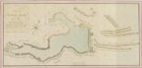
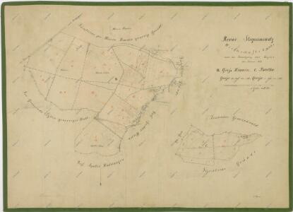
Geometrický plán Spolského rybníka, chalup na jeho hrázi a přilehlých pozemků 1

Břilice o. Jindřichův Hradec 1
1 : 2880
Libin - c4013-1-003 - Kaiserpflichtexemplar der Landkarten des stabilen Katasters
1 : 2880
Libin - c4013-1-001 - Kaiserpflichtexemplar der Landkarten des stabilen Katasters
1 : 2880
Libin - c4013-1-005 - Kaiserpflichtexemplar der Landkarten des stabilen Katasters
1 : 2880
Libin - c4013-1-002 - Kaiserpflichtexemplar der Landkarten des stabilen Katasters
1 : 2880
Libin - c4013-1-004 - Kaiserpflichtexemplar der Landkarten des stabilen Katasters
1 : 2880
Spolly - c7179-1-003 - Kaiserpflichtexemplar der Landkarten des stabilen Katasters
1 : 2880
Spolly - c7179-1-001 - Kaiserpflichtexemplar der Landkarten des stabilen Katasters
1 : 2880
Spolly - c7179-1-004 - Kaiserpflichtexemplar der Landkarten des stabilen Katasters
1 : 2880