Maps of Novosedly nad Nežárkou
Hospodářská mapa polesí Mláka 1
1 : 2880
Hospodářská mapa polesí Mláka 1
1 : 2880
Hospodářská mapa polesí Mláka 1
1 : 2880
Porostní obrysová mapa polesí Kolence 1
1 : 10000
Porostní mapa polesí Mláka 1
1 : 10000
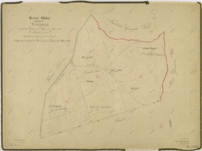
Neusattel - c5305-1-006 - Kaiserpflichtexemplar der Landkarten des stabilen Katasters
1 : 2880
Neusattel - c5305-1-001 - Kaiserpflichtexemplar der Landkarten des stabilen Katasters
1 : 2880
Neusattel - c5305-1-009 - Kaiserpflichtexemplar der Landkarten des stabilen Katasters
1 : 2880
Neusattel - c5305-1-003 - Kaiserpflichtexemplar der Landkarten des stabilen Katasters
1 : 2880
Neusattel - c5305-1-002 - Kaiserpflichtexemplar der Landkarten des stabilen Katasters
1 : 2880
Neusattel - c5305-1-007 - Kaiserpflichtexemplar der Landkarten des stabilen Katasters
1 : 2880
Neusattel - c5305-1-010 - Kaiserpflichtexemplar der Landkarten des stabilen Katasters
1 : 2880
Neusattel - c5305-1-004 - Kaiserpflichtexemplar der Landkarten des stabilen Katasters
1 : 2880
Neusattel - c5305-1-011 - Kaiserpflichtexemplar der Landkarten des stabilen Katasters
1 : 2880
Neusattel - c5305-1-005 - Kaiserpflichtexemplar der Landkarten des stabilen Katasters
1 : 2880
Neusattel - c5305-1-008 - Kaiserpflichtexemplar der Landkarten des stabilen Katasters
1 : 2880
Hospodářská mapa polesí Kolence 1
1 : 2880
Lužnice o. Jindřichův Hradec 1
1 : 2880
Porostní mapa polesí Mláka 1

Porostní mapa polesí Mláka s vyznačením bonity půdy 1
1 : 15000
Porostní mapa polesí Kolence 1
1 : 15000
Porostní mapa polesí Kolence 1
1 : 15000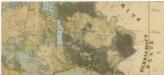
Administrativní mapa třeboňského panství se statky Bzí,Lomnice, Borovany,Hamr a Val 1
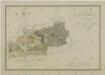
Situační plán statku Hamr-Val a přilehlých pozemků 1

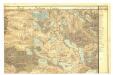
Gradkartenblatt
1 : 25000 Třeboň-oblast (Česko) Gerstner, Eduard von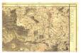

Mapa porostů hlavního komplexu Třeboňského polesí náležejících revírů Kolenec, Mláka, Zámecký revír, Sv. Barbora, Cep a Hrdlořez, pro exkursi České lesnické jednoty v roce 1909 1
1 : 30000