Maps of Borovany

Hospodářská mapa polesí Jílovice 1
1 : 2880
Porostní mapa polesí Borovany 1

Mapa lesních cest v polesí Jílovice 1
1 : 10000
Porostní mapa polesí Jílovice 1
1 : 10000
Porostní obrysová mapa polesí Jílovice 1
1 : 10000
Hluboká o. České Budějovice 1
1 : 2880
Jílovice o. České Budějovice 1
1 : 2880
Porostní mapa polesí Borovany 1

Hospodářská mapa polesí Jílovice 1
1 : 2880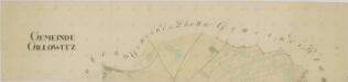
Jílovice o. České Budějovice 1
1 : 2880
Jílovice o. České Budějovice 1
1 : 2880
Jílovice o. České Budějovice 1
1 : 2880
Porostní mapa polesí Borovany 1
Porostní mapa polesí Borovany lesní komplex Jílovice 1
1 : 15000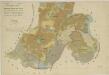
Přehledná mapa vrchnostenských pozemků v polesí Jílovice 1

Generální mapa panství Třeboň a inkorporovaných statků Bzí, Lomnice, Borovany, Třeboň, Hamr a Val 1
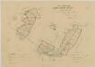
Geometrický plán vsi Jílovice a přilehlých pozemků a jejich hranic

Hluboka - c1893-1-007 - Kaiserpflichtexemplar der Landkarten des stabilen Katasters
1 : 2880
Hluboka - c1893-1-008 - Kaiserpflichtexemplar der Landkarten des stabilen Katasters
1 : 2880
Hluboka - c1893-1-004 - Kaiserpflichtexemplar der Landkarten des stabilen Katasters
1 : 2880
Hluboka - c1893-1-006 - Kaiserpflichtexemplar der Landkarten des stabilen Katasters
1 : 2880
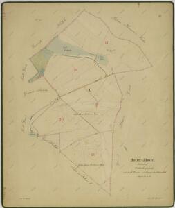
Hluboka - c1893-1-001 - Kaiserpflichtexemplar der Landkarten des stabilen Katasters
1 : 2880
Hluboka - c1893-1-005 - Kaiserpflichtexemplar der Landkarten des stabilen Katasters
1 : 2880
Hluboka - c1893-1-003 - Kaiserpflichtexemplar der Landkarten des stabilen Katasters
1 : 2880
Hluboka - c1893-1-002 - Kaiserpflichtexemplar der Landkarten des stabilen Katasters
1 : 2880
Gillowitz - c2900-1-001 - Kaiserpflichtexemplar der Landkarten des stabilen Katasters
1 : 2880
Gillowitz - c2900-1-002 - Kaiserpflichtexemplar der Landkarten des stabilen Katasters
1 : 2880
Gillowitz - c2900-1-003 - Kaiserpflichtexemplar der Landkarten des stabilen Katasters
1 : 2880
Gillowitz - c2900-1-005 - Kaiserpflichtexemplar der Landkarten des stabilen Katasters
1 : 2880
Gillowitz - c2900-1-004 - Kaiserpflichtexemplar der Landkarten des stabilen Katasters
1 : 2880
Gillowitz - c2900-1-007 - Kaiserpflichtexemplar der Landkarten des stabilen Katasters
1 : 2880