Maps of Dvory nad Lužnicí

Brouillon hospodářské mapy hrdlořezských bažin 1
Geometrický plán blat v polesí Hrdlořezy
Přehledná hospodářská mapa velkostatku Třeboň 1
1 : 11250
Podrobný plán odvodnění Červeného blata v polesí Hrdlořezy

Revír Hrdlořezy. Porostní obrysová mapa revíru Hrdlořezy 1
1 : 15000
Administrativní mapa třeboňského panství se statky Bzí,Lomnice, Borovany,Hamr a Val 1

Generální mapa panství Třeboň a inkorporovaných statků Bzí, Lomnice, Borovany, Třeboň, Hamr a Val 1

Porostní mapa polesí Hrdlořezy 1
1 : 10000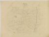
Porostní obrysová mapa polesí Cep 1
1 : 15000
Porostní obrysová mapa polesí Cep 1
1 : 15000
Porostní mapa polesí Cep 1
1 : 15000
Porostní mapa polesí Cep 1
1 : 15000
Porostní mapa polesí Cep 1
1 : 15000
Mapa lesních cest v polesí Cep 1
1 : 15000
Porostní mapa polesí Cep 1
1 : 15000
Přehledná mapa polesí Jílovice 1

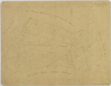
Mapa sporných pozemků tzv. Červeného blata mezi třeboňským a novohradským panstvím u vsi Hrdlořezy

Porostní mapa polesí Hrdlořezy 1
1 : 15000
Böhmdorf - c0708-1-007 - Kaiserpflichtexemplar der Landkarten des stabilen Katasters
1 : 2880
Böhmdorf - c0708-1-001 - Kaiserpflichtexemplar der Landkarten des stabilen Katasters
1 : 2880
Böhmdorf - c0708-1-005 - Kaiserpflichtexemplar der Landkarten des stabilen Katasters
1 : 2880
Böhmdorf - c0708-1-011 - Kaiserpflichtexemplar der Landkarten des stabilen Katasters
1 : 2880
Böhmdorf - c0708-1-004 - Kaiserpflichtexemplar der Landkarten des stabilen Katasters
1 : 2880
Böhmdorf - c0708-1-015 - Kaiserpflichtexemplar der Landkarten des stabilen Katasters
1 : 2880
Böhmdorf - c0708-1-014 - Kaiserpflichtexemplar der Landkarten des stabilen Katasters
1 : 2880
Böhmdorf - c0708-1-008 - Kaiserpflichtexemplar der Landkarten des stabilen Katasters
1 : 2880
Böhmdorf - c0708-1-017 - Kaiserpflichtexemplar der Landkarten des stabilen Katasters
1 : 2880
Böhmdorf - c0708-1-012 - Kaiserpflichtexemplar der Landkarten des stabilen Katasters
1 : 2880
Böhmdorf - c0708-1-003 - Kaiserpflichtexemplar der Landkarten des stabilen Katasters
1 : 2880
Böhmdorf - c0708-1-016 - Kaiserpflichtexemplar der Landkarten des stabilen Katasters
1 : 2880
Böhmdorf - c0708-1-002 - Kaiserpflichtexemplar der Landkarten des stabilen Katasters
1 : 2880
Böhmdorf - c0708-1-010 - Kaiserpflichtexemplar der Landkarten des stabilen Katasters
1 : 2880
Böhmdorf - c0708-1-009 - Kaiserpflichtexemplar der Landkarten des stabilen Katasters
1 : 2880
Böhmdorf - c0708-1-006 - Kaiserpflichtexemplar der Landkarten des stabilen Katasters
1 : 2880