Maps of Drahov

Hamr o. Tábor 1
1 : 2880
Hammer - c1766-1-001 - Kaiserpflichtexemplar der Landkarten des stabilen Katasters
1 : 2880
Hammer - c1766-1-002 - Kaiserpflichtexemplar der Landkarten des stabilen Katasters
1 : 2880
Mapy činžovních pozemků I. sekce třeboňského velkostatku pro obce: Borkovice, Bošilec, Drahotěšice, Frahelž, Hamr, Horusice, Lhota, Líšnice, Mažice, Mezimostí, Ponědraž, Ponědrážka, Řípec, Val, Vlkov 1
1 : 2880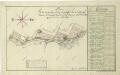
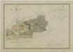
Geometrický plán 12 dominikálních domků u Hamru s přilehlými pozemky
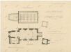
Plán hamerského kostela 1
1 : 100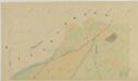
Vlkov o. Tábor 1
1 : 2880
Mapy činžovních pozemků I. sekce třeboňského velkostatku pro obce: Borkovice, Bošilec, Drahotěšice, Frahelž, Hamr, Horusice, Lhota, Líšnice, Mažice, Mezimostí, Ponědraž, Ponědrážka, Řípec, Val, Vlkov 1
1 : 2880
Mapa pronajatých pozemků dvora Val 1

Mapa pozemků dvora Val 1

Mapa pozemků dvora Dehetník 1

Mapa pozemků dvora Dehetník 1
1 : 5760
Mapa pozemků dvora Val 1
1 : 5760
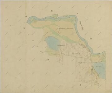
Drahles - c1503-1-006 - Kaiserpflichtexemplar der Landkarten des stabilen Katasters
1 : 2880
Drahles - c1503-1-003 - Kaiserpflichtexemplar der Landkarten des stabilen Katasters
1 : 2880
Drahles - c1503-1-002 - Kaiserpflichtexemplar der Landkarten des stabilen Katasters
1 : 2880
Drahles - c1503-1-005 - Kaiserpflichtexemplar der Landkarten des stabilen Katasters
1 : 2880
Drahles - c1503-1-001 - Kaiserpflichtexemplar der Landkarten des stabilen Katasters
1 : 2880
Drahles - c1503-1-004 - Kaiserpflichtexemplar der Landkarten des stabilen Katasters
1 : 2880
Vlkov o. Tábor 1
1 : 2880
Porostní mapa polesí Val 1
1 : 10000
Porostní obrysová mapa polesí Val 1
1 : 10000
Generální mapa panství Třeboň a inkorporovaných statků Bzí, Lomnice, Borovany, Třeboň, Hamr a Val 1

Porostní mapa polesí Val 1
1 : 15000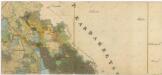
Administrativní mapa třeboňského panství se statky Bzí,Lomnice, Borovany,Hamr a Val 1

Generální mapa panství Třeboň a inkorporovaných statků Bzí, Lomnice, Borovany, Třeboň, Hamr a Val 1
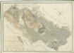
Přehledná mapa pozemků statku Hamr-Val a lesů koleneckého polesí 1
Situační plán statku Hamr-Val a přilehlých pozemků 1

III. vojenské mapování 4353/2
1 : 25000