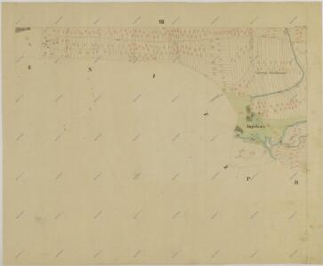
Maps of Smržov u Lomnice nad Lužnicí

Smržov o. Jindřichův Hradec 1
1 : 2880
Půdorysný plán bošilecké bašty a myslivny u rybníka Dvořiště s přilehlými hospodářskými budovami 1

Porostní mapa polesí Lomnice 1

Porostní mapa polesí Dvořiště 1
1 : 10000
Smrzow - c7096-1-004 - Kaiserpflichtexemplar der Landkarten des stabilen Katasters
1 : 2880
Smrzow - c7096-1-005 - Kaiserpflichtexemplar der Landkarten des stabilen Katasters
1 : 2880
Smrzow - c7096-1-002 - Kaiserpflichtexemplar der Landkarten des stabilen Katasters
1 : 2880
Smrzow - c7096-1-007 - Kaiserpflichtexemplar der Landkarten des stabilen Katasters
1 : 2880
Smrzow - c7096-1-001 - Kaiserpflichtexemplar der Landkarten des stabilen Katasters
1 : 2880
Smrzow - c7096-1-006 - Kaiserpflichtexemplar der Landkarten des stabilen Katasters
1 : 2880
Smrzow - c7096-1-003 - Kaiserpflichtexemplar der Landkarten des stabilen Katasters
1 : 2880
Unt. Slowenitz - c1389-1-001 - Kaiserpflichtexemplar der Landkarten des stabilen Katasters
1 : 2880
Unt. Slowenitz - c1389-1-005 - Kaiserpflichtexemplar der Landkarten des stabilen Katasters
1 : 2880
Unt. Slowenitz - c1389-1-004 - Kaiserpflichtexemplar der Landkarten des stabilen Katasters
1 : 2880
Unt. Slowenitz - c1389-1-003 - Kaiserpflichtexemplar der Landkarten des stabilen Katasters
1 : 2880
Unt. Slowenitz - c1389-1-006 - Kaiserpflichtexemplar der Landkarten des stabilen Katasters
1 : 2880
Unt. Slowenitz - c1389-1-002 - Kaiserpflichtexemplar der Landkarten des stabilen Katasters
1 : 2880
Smržov o. Jindřichův Hradec 1
1 : 2880
Geometrický plán rybníka Koclířov s přilehlými činžovními pozemky

Porostní mapa polesí Dvořiště 1
Geometrický plán rybníků Velký a Malý Tisý a Koclířov

Přehledná mapa polesí Dvořiště 1

III. vojenské mapování 4353/4
1 : 25000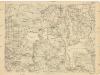
[Gradkartenblatt]
1 : 25000 Třeboň-oblast (Česko)
Gradkartenblatt
1 : 25000 Třeboň-oblast (Česko) Gerstner, Eduard von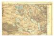
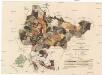
Bestandskarte für die Excoursionstour des böhm. Forstvereins im August 1876 auf der Herrschaft Frauenberg
Hluboká nad Vltavou-oblast (Česko) Danesch, Jos. Renard
Podrobné mapy zemí Koruny české v měřítku 1:75.000 a mapa vzdáleností všech míst při silnici ležících - Veselí - Lomnice - Hluboká. Průvodce statisticko-historický po všech místech na těchto mapách uvedených a rejstřík věcný názvů hor, potoků, řek, rybníků atd. Sešit 27. List 60,
1 : 75000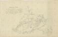
Situační plán vodní soustavy v jihozápadní části Třeboňské pánve