Maps of Dunajovice

Dunajovice o. Jindřichův Hradec 1
1 : 2880
Mapy činžovních pozemků II. sekce třeboňského velkostatku pro obce: Dolní Slověnice, Dunajovice, Klec, Kolence, Lomnice, Lužnice, Mláka, Novosedly, Smržov, Stará Hlína 1
1 : 2880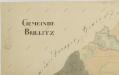
Břilice o. Jindřichův Hradec 1
1 : 2880
Horní Miletín o. České Budějovice 1
1 : 2880
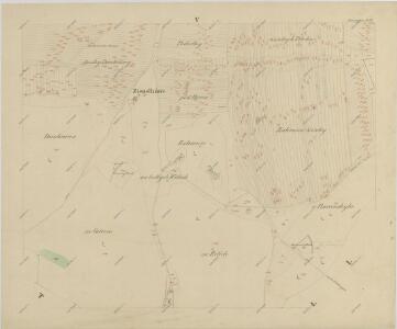
Dunagitz - c1608-1-004 - Kaiserpflichtexemplar der Landkarten des stabilen Katasters
1 : 2880
Dunagitz - c1608-1-002 - Kaiserpflichtexemplar der Landkarten des stabilen Katasters
1 : 2880
Dunagitz - c1608-1-003 - Kaiserpflichtexemplar der Landkarten des stabilen Katasters
1 : 2880
Dunagitz - c1608-1-001 - Kaiserpflichtexemplar der Landkarten des stabilen Katasters
1 : 2880
Dunagitz - c1608-1-005 - Kaiserpflichtexemplar der Landkarten des stabilen Katasters
1 : 2880
Brzillitz - c0612-1-003 - Kaiserpflichtexemplar der Landkarten des stabilen Katasters
1 : 2880
Brzillitz - c0612-1-002 - Kaiserpflichtexemplar der Landkarten des stabilen Katasters
1 : 2880
Brzillitz - c0612-1-004 - Kaiserpflichtexemplar der Landkarten des stabilen Katasters
1 : 2880
Brzillitz - c0612-1-008 - Kaiserpflichtexemplar der Landkarten des stabilen Katasters
1 : 2880
Brzillitz - c0612-1-006 - Kaiserpflichtexemplar der Landkarten des stabilen Katasters
1 : 2880
Brzillitz - c0612-1-001 - Kaiserpflichtexemplar der Landkarten des stabilen Katasters
1 : 2880
Brzillitz - c0612-1-007 - Kaiserpflichtexemplar der Landkarten des stabilen Katasters
1 : 2880
Brzillitz - c0612-1-005 - Kaiserpflichtexemplar der Landkarten des stabilen Katasters
1 : 2880
Horní a Dolní Miletín o. České Budějovice 1
1 : 2880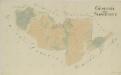
Horní Slověnice o. České Budějovice 1
1 : 2880
Ober Milletin - c2100-1-001 - Kaiserpflichtexemplar der Landkarten des stabilen Katasters
1 : 2880
Ober Milletin - c2100-1-002 - Kaiserpflichtexemplar der Landkarten des stabilen Katasters
1 : 2880
Ober Slowenitz - c2151-1-003 - Kaiserpflichtexemplar der Landkarten des stabilen Katasters
1 : 2880
Ober Slowenitz - c2151-1-001 - Kaiserpflichtexemplar der Landkarten des stabilen Katasters
1 : 2880
Ober Slowenitz - c2151-1-002 - Kaiserpflichtexemplar der Landkarten des stabilen Katasters
1 : 2880
Dunajovice o. Jindřichův Hradec 1
1 : 2880
Dunajovice o. Jindřichův Hradec 1
1 : 2880
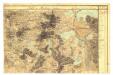
III. vojenské mapování 4353/4
1 : 25000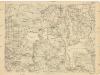
[Gradkartenblatt]
1 : 25000 Třeboň-oblast (Česko)
Gradkartenblatt
1 : 25000 Třeboň-oblast (Česko) Gerstner, Eduard von