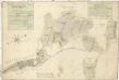
Maps of Hluboká nad Vltavou

Líšnice o. České Budějovice 1
1 : 2880
Mapy činžovních pozemků I. sekce třeboňského velkostatku pro obce: Borkovice, Bošilec, Drahotěšice, Frahelž, Hamr, Horusice, Lhota, Líšnice, Mažice, Mezimostí, Ponědraž, Ponědrážka, Řípec, Val, Vlkov 1
1 : 2880
Mapy činžovních pozemků I. sekce třeboňského velkostatku pro obce: Borkovice, Bošilec, Drahotěšice, Frahelž, Hamr, Horusice, Lhota, Líšnice, Mažice, Mezimostí, Ponědraž, Ponědrážka, Řípec, Val, Vlkov 1
1 : 2880
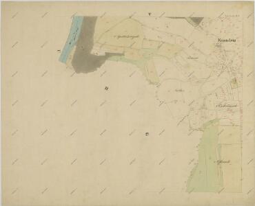
Geometrický plán lesů, činžovních, farních a služebních pozemků v okolí Kostelce 1
Líšnice o. České Budějovice 1
1 : 2880
Porostní mapa polesí Poněšice 1

Lischnitz - c4143-1-001 - Kaiserpflichtexemplar der Landkarten des stabilen Katasters
1 : 2880
Lischnitz - c4143-1-008 - Kaiserpflichtexemplar der Landkarten des stabilen Katasters
1 : 2880
Lischnitz - c4143-1-004 - Kaiserpflichtexemplar der Landkarten des stabilen Katasters
1 : 2880
Lischnitz - c4143-1-010 - Kaiserpflichtexemplar der Landkarten des stabilen Katasters
1 : 2880
Lischnitz - c4143-1-005 - Kaiserpflichtexemplar der Landkarten des stabilen Katasters
1 : 2880
Lischnitz - c4143-1-003 - Kaiserpflichtexemplar der Landkarten des stabilen Katasters
1 : 2880
Lischnitz - c4143-1-002 - Kaiserpflichtexemplar der Landkarten des stabilen Katasters
1 : 2880
Lischnitz - c4143-1-007 - Kaiserpflichtexemplar der Landkarten des stabilen Katasters
1 : 2880
Lischnitz - c4143-1-006 - Kaiserpflichtexemplar der Landkarten des stabilen Katasters
1 : 2880
Lischnitz - c4143-1-009 - Kaiserpflichtexemplar der Landkarten des stabilen Katasters
1 : 2880
Purgholz - c6284-1-003 - Kaiserpflichtexemplar der Landkarten des stabilen Katasters
1 : 2880
Purgholz - c6284-1-005 - Kaiserpflichtexemplar der Landkarten des stabilen Katasters
1 : 2880
Purgholz - c6284-1-002 - Kaiserpflichtexemplar der Landkarten des stabilen Katasters
1 : 2880
Purgholz - c6284-1-004 - Kaiserpflichtexemplar der Landkarten des stabilen Katasters
1 : 2880
Purgholz - c6284-1-001 - Kaiserpflichtexemplar der Landkarten des stabilen Katasters
1 : 2880
Přehledná mapa polesí Radonice 1
Geometrický plán vrchnostenských lesů v purkareckém a litoradlickém revíru 1

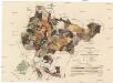
Generální mapa panství Třeboň a inkorporovaných statků Bzí, Lomnice, Borovany, Třeboň, Hamr a Val 1
Administrativní mapa třeboňského panství se statky Bzí,Lomnice, Borovany,Hamr a Val 1

[Gradkartenblatt]
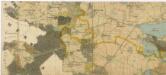
1 : 25000 Týn nad Vltavou-oblast (Česko) Vojenský zeměpisný ústav
III. vojenské mapování 4353/1
1 : 25000
Gradkartenblatt
1 : 25000 Týn nad Vltavou-oblast (Česko) Gerstner, Eduard von