Maps of Suchdol nad Lužnicí

Mapy činžovních pozemků VI. sekce třeboňského velkostatku pro obce Hrdlořezy a Suchdol 1
1 : 2880
Mapy činžovních pozemků VI. sekce třeboňského velkostatku pro obce Hrdlořezy a Suchdol 1
Mapa činžovních pozemků obce Suchdol patřící do VI. sekce třeboňského velkostatku 1
Cep o. Jindřichův Hradec 1
1 : 2880
Cep o. Jindřichův Hradec 1
1 : 2880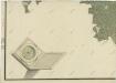
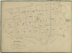
Geometrický plán polesí Cep

Hospodářská mapa polesí Cep 1
1 : 5760
Hospodářská mapa polesí Cep 1
1 : 5760
Porostní mapa části polesí Cep-Suchdol 1
Hospodářská mapa polesí Cep 1

Mapy činžovních pozemků V. sekce třeboňského velkostatku pro obce: Bor, Cep, Jílovice, Kramolín, Lipnice, Šalmanovice 1

Hospodářská mapa polesí Cep 1

Cep o. Jidndřichův Hradec 1
1 : 2880
Geometrický plán lesů Spálený, Vejpustek pod Smolkem a rybníků Smolek, Heřman a Joch s přilehlými činžovními pozemky

Mapy činžovních pozemků VI. sekce třeboňského velkostatku pro obce Hrdlořezy a Suchdol 1

Plán železniční tratě v úseku Gmünd - Veselí nad Lužnicí, list 3 1

Cep o. Jindřichův Hradec 1
1 : 2880
Cep o. Jindřichův Hradec 1
1 : 2880
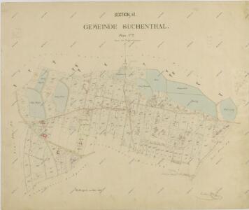
Suchenthal - c7551-1-007 - Kaiserpflichtexemplar der Landkarten des stabilen Katasters
1 : 2880
Suchenthal - c7551-1-005 - Kaiserpflichtexemplar der Landkarten des stabilen Katasters
1 : 2880
Suchenthal - c7551-1-006 - Kaiserpflichtexemplar der Landkarten des stabilen Katasters
1 : 2880
Suchenthal - c7551-1-010 - Kaiserpflichtexemplar der Landkarten des stabilen Katasters
1 : 2880
Suchenthal - c7551-1-009 - Kaiserpflichtexemplar der Landkarten des stabilen Katasters
1 : 2880
Suchenthal - c7551-1-002 - Kaiserpflichtexemplar der Landkarten des stabilen Katasters
1 : 2880
Suchenthal - c7551-1-004 - Kaiserpflichtexemplar der Landkarten des stabilen Katasters
1 : 2880
Suchenthal - c7551-1-001 - Kaiserpflichtexemplar der Landkarten des stabilen Katasters
1 : 2880
Suchenthal - c7551-1-003 - Kaiserpflichtexemplar der Landkarten des stabilen Katasters
1 : 2880
Suchenthal - c7551-1-008 - Kaiserpflichtexemplar der Landkarten des stabilen Katasters
1 : 2880
Mapa tzv. rybářské cesty z Lišova do Schwartzbachu na rakouské hranici 1