Maps of Bezirk Gmünd

Mapy činžovních pozemků VI. sekce třeboňského velkostatku pro obce Hrdlořezy a Suchdol 1
Plán nových dominikálních pozemků osídlenců v Hrdlořezích a Boru 1

Mapy činžovních pozemků VI. sekce třeboňského velkostatku pro obce Hrdlořezy a Suchdol 1
Mapy činžovních pozemků V. sekce třeboňského velkostatku pro obce: Cep, Hrdlořezy, Jílovice, Kramolín, Šalmanovice 1

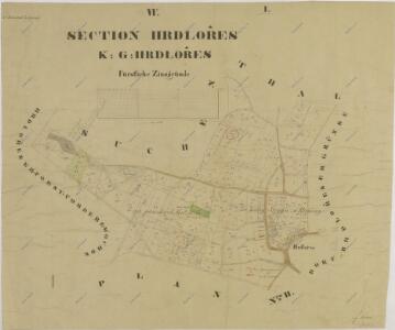
Hospodářská mapa polesí Hrdlořezy 1
1 : 2880
Geometrický plán lesa Borek u Německého, mysliveckých deputátních pozemků a jiterních pozemků u vsi Hrdlořezy

Hrdlorzes - c2348-1-004 - Kaiserpflichtexemplar der Landkarten des stabilen Katasters
1 : 2880
Hrdlorzes - c2348-1-005 - Kaiserpflichtexemplar der Landkarten des stabilen Katasters
1 : 2880
Hrdlorzes - c2348-1-006 - Kaiserpflichtexemplar der Landkarten des stabilen Katasters
1 : 2880
Hrdlorzes - c2348-1-007 - Kaiserpflichtexemplar der Landkarten des stabilen Katasters
1 : 2880
Hrdlorzes - c2348-1-012 - Kaiserpflichtexemplar der Landkarten des stabilen Katasters
1 : 2880
Hrdlorzes - c2348-1-011 - Kaiserpflichtexemplar der Landkarten des stabilen Katasters
1 : 2880
Hrdlorzes - c2348-1-010 - Kaiserpflichtexemplar der Landkarten des stabilen Katasters
1 : 2880
Hrdlorzes - c2348-1-002 - Kaiserpflichtexemplar der Landkarten des stabilen Katasters
1 : 2880
Hrdlorzes - c2348-1-001 - Kaiserpflichtexemplar der Landkarten des stabilen Katasters
1 : 2880
Hrdlorzes - c2348-1-008 - Kaiserpflichtexemplar der Landkarten des stabilen Katasters
1 : 2880
Hrdlorzes - c2348-1-009 - Kaiserpflichtexemplar der Landkarten des stabilen Katasters
1 : 2880
Hrdlorzes - c2348-1-003 - Kaiserpflichtexemplar der Landkarten des stabilen Katasters
1 : 2880
Hrdlořezy o. Jindřichův Hradec 1
1 : 2880
Plán hlavního kanálu v polesí Hrdlořezy

Hospodářská mapa polesí Hrdlořezy 1

Brouillon hospodářské mapy polesí Hrdlořezy 1

Hospodářská mapa polesí Hrdlořezy 1
1 : 2880
Přehledná mapa polesí Hrdlořezy

Porostní mapa polesí Hrdlořezy 1
1 : 10000
Porostní mapa polesí Hrdlořezy 1
1 : 10000
Odvodňovací mapa polesí Hrdlořezy 1
1 : 10000
Porostní mapa polesí Hrdlořezy 1

Porostní mapa polesí Hrdlořezy 1
1 : 15000