Maps of Nedabyle

Mapy činžovních pozemků IV. sekce třeboňského velkostatku pro obce: Dolní Miletín, Doubravice, Doudleby, Hodovice, Horní Miletín, Ledenice, Nový Dvůr, Petrovice, Slavošovice, Štěpánovice, Zborov 1

Doubravice o. České Budějovice 1
1 : 2880
Daubrawitz - c1464-1-001 - Kaiserpflichtexemplar der Landkarten des stabilen Katasters
1 : 2880
Daubrawitz - c1464-1-004 - Kaiserpflichtexemplar der Landkarten des stabilen Katasters
1 : 2880
Daubrawitz - c1464-1-003 - Kaiserpflichtexemplar der Landkarten des stabilen Katasters
1 : 2880
Daubrawitz - c1464-1-002 - Kaiserpflichtexemplar der Landkarten des stabilen Katasters
1 : 2880
Hodowitz - c1922-1-006 - Kaiserpflichtexemplar der Landkarten des stabilen Katasters
1 : 2880
Hodowitz - c1922-1-001 - Kaiserpflichtexemplar der Landkarten des stabilen Katasters
1 : 2880
Hodowitz - c1922-1-002 - Kaiserpflichtexemplar der Landkarten des stabilen Katasters
1 : 2880
Hodowitz - c1922-1-005 - Kaiserpflichtexemplar der Landkarten des stabilen Katasters
1 : 2880
Hodowitz - c1922-1-008 - Kaiserpflichtexemplar der Landkarten des stabilen Katasters
1 : 2880
Hodowitz - c1922-1-003 - Kaiserpflichtexemplar der Landkarten des stabilen Katasters
1 : 2880
Hodowitz - c1922-1-004 - Kaiserpflichtexemplar der Landkarten des stabilen Katasters
1 : 2880
Hodowitz - c1922-1-007 - Kaiserpflichtexemplar der Landkarten des stabilen Katasters
1 : 2880
Neudorf - c5211-1-001 - Kaiserpflichtexemplar der Landkarten des stabilen Katasters
1 : 2880
Neudorf - c5211-1-006 - Kaiserpflichtexemplar der Landkarten des stabilen Katasters
1 : 2880
Neudorf - c5211-1-002 - Kaiserpflichtexemplar der Landkarten des stabilen Katasters
1 : 2880
Neudorf - c5211-1-003 - Kaiserpflichtexemplar der Landkarten des stabilen Katasters
1 : 2880
Neudorf - c5211-1-004 - Kaiserpflichtexemplar der Landkarten des stabilen Katasters
1 : 2880
Neudorf - c5211-1-005 - Kaiserpflichtexemplar der Landkarten des stabilen Katasters
1 : 2880
Plán železniční tratě v úseku Gmünd - České Budějovice, list 6 1
Geometrický plán lesa Březová stráň, zrušených rybníků Tyrského a Nového, přilehlých činžovních pozemků a zásobních luk u Vidova 1

Hodonice o. Tábor 1
1 : 2880
Mapy činžovních pozemků IV. sekce třeboňského velkostatku pro obce: Ledenice, Zaliny, Jílovice, Petrovice, Doudleby, Hodovice, Nový Dvůr, Hůrka, Zborov, Borovany, Hluboká u Borovan, Štěpánovice, Slavošovice, Horní Miletín 1
1 : 2880
Porostní mapa polesí Zborov 1
1 : 10000
Porostní mapa polesí Zborov 1
1 : 10000
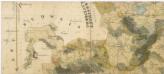
Generální mapa panství Třeboň a inkorporovaných statků Bzí, Lomnice, Borovany, Třeboň, Hamr a Val 1
Porostní mapa polesí Zborov 1
1 : 15000
České Budějovice se situačním plánkem letiště