Maps of Libín

Mapy činžovních pozemků III. sekce třeboňského velkostatku pro obce: Branná, Břilice, Domanín, Herda, Holičky, Kojákovice, Spolí, Třeboň 1

Mapy činžovních pozemků III. sekce třeboňského velkostatku pro obce: Branná, Břilice, Domanín, Herda, Holičky, Kojákovice, Spolí 1

kopie-kopie-kopie-Mapy činžovních pozemků III. sekce třeboňského velkostatku pro obce: Břilice, Domanín, Herda, Holičky, Kojákovice, Spolí, Třeboň 1
1 : 2880
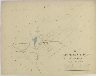
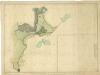
Spolly - c7179-1-003 - Kaiserpflichtexemplar der Landkarten des stabilen Katasters
1 : 2880
Spolly - c7179-1-001 - Kaiserpflichtexemplar der Landkarten des stabilen Katasters
1 : 2880
Spolly - c7179-1-004 - Kaiserpflichtexemplar der Landkarten des stabilen Katasters
1 : 2880
Spolly - c7179-1-002 - Kaiserpflichtexemplar der Landkarten des stabilen Katasters
1 : 2880
Domanín o. Jindřichův Hradec 1
1 : 2880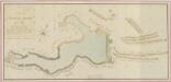
Geometrický plán Spolského rybníka, chalup na jeho hrázi a přilehlých pozemků 1
Hospodářská mapa polesí Štěpánovice 1

Záměrná mapa rybníků a lesů u Branné

Libin - c4013-1-003 - Kaiserpflichtexemplar der Landkarten des stabilen Katasters
1 : 2880
Libin - c4013-1-001 - Kaiserpflichtexemplar der Landkarten des stabilen Katasters
1 : 2880
Libin - c4013-1-005 - Kaiserpflichtexemplar der Landkarten des stabilen Katasters
1 : 2880
Libin - c4013-1-002 - Kaiserpflichtexemplar der Landkarten des stabilen Katasters
1 : 2880
Libin - c4013-1-004 - Kaiserpflichtexemplar der Landkarten des stabilen Katasters
1 : 2880
Domanín o. Jindřichův Hradec 1
1 : 2880
Domanin - c1424-1-006 - Kaiserpflichtexemplar der Landkarten des stabilen Katasters
1 : 2880
Domanin - c1424-1-007 - Kaiserpflichtexemplar der Landkarten des stabilen Katasters
1 : 2880
Domanin - c1424-1-002 - Kaiserpflichtexemplar der Landkarten des stabilen Katasters
1 : 2880
Domanin - c1424-1-001 - Kaiserpflichtexemplar der Landkarten des stabilen Katasters
1 : 2880
Domanin - c1424-1-004 - Kaiserpflichtexemplar der Landkarten des stabilen Katasters
1 : 2880
Domanin - c1424-1-003 - Kaiserpflichtexemplar der Landkarten des stabilen Katasters
1 : 2880
Domanin - c1424-1-005 - Kaiserpflichtexemplar der Landkarten des stabilen Katasters
1 : 2880
Libín o. České Budějovice 1
1 : 2880
Domanín o. Jindřichův Hradec 1
1 : 2880
Generální mapa panství Třeboň a inkorporovaných statků Bzí, Lomnice, Borovany, Třeboň, Hamr a Val 1

Situační plán erární silnice od dvora Kuna do Ledenic 1
Plán rybníka a luk u Cepu