Maps of Bošilec

Přehledná mapa polesí Bošilec 1

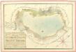
Geometrický plán Horusického rybníka, deputátních a činžovních pozemků 1

Horusitz - c2195-1-006 - Kaiserpflichtexemplar der Landkarten des stabilen Katasters
1 : 2880
Horusitz - c2195-1-003 - Kaiserpflichtexemplar der Landkarten des stabilen Katasters
1 : 2880
Horusitz - c2195-1-001 - Kaiserpflichtexemplar der Landkarten des stabilen Katasters
1 : 2880
Horusitz - c2195-1-004 - Kaiserpflichtexemplar der Landkarten des stabilen Katasters
1 : 2880
Horusitz - c2195-1-008 - Kaiserpflichtexemplar der Landkarten des stabilen Katasters
1 : 2880
Horusitz - c2195-1-007 - Kaiserpflichtexemplar der Landkarten des stabilen Katasters
1 : 2880
Horusitz - c2195-1-005 - Kaiserpflichtexemplar der Landkarten des stabilen Katasters
1 : 2880
Horusitz - c2195-1-002 - Kaiserpflichtexemplar der Landkarten des stabilen Katasters
1 : 2880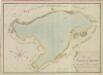
Geometrický plán Bošileckého rybníka a přilehlých pozemků 1

Boschilletz - c0425-1-003 - Kaiserpflichtexemplar der Landkarten des stabilen Katasters
1 : 2880
Boschilletz - c0425-1-001 - Kaiserpflichtexemplar der Landkarten des stabilen Katasters
1 : 2880
Boschilletz - c0425-1-005 - Kaiserpflichtexemplar der Landkarten des stabilen Katasters
1 : 2880
Boschilletz - c0425-1-002 - Kaiserpflichtexemplar der Landkarten des stabilen Katasters
1 : 2880
Boschilletz - c0425-1-006 - Kaiserpflichtexemplar der Landkarten des stabilen Katasters
1 : 2880
Boschilletz - c0425-1-004 - Kaiserpflichtexemplar der Landkarten des stabilen Katasters
1 : 2880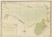
Geometrický plán Horusického rybníka, deputátních a činžovních pozemků 1
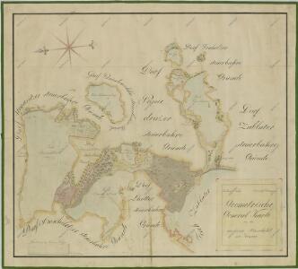
Geometrický plán bošileckého lesa, rybníků Linýř, Kvíčadlo a Švambírek, činžovních, deputátních a farních pozemků 1
Geometrický plán rybníků Bošilec, Ponědráž a Švarcenberk
Geometrický plán rybníka Švancenberk s přilehlými pozemky 1

Ponědrážka o. Jindřichův Hradec 1
1 : 2880
Bošilec o. České Budějovice 1
1 : 2880
Horusice o. Tábor 1
1 : 2880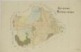
Ponědrážka o. Jindřichův Hradec 1
1 : 2880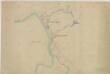
Mapa povodí Zlaté stoky překopírované z katastrálních map přilehlých obcí 1
1 : 2880
Poniedražko - c6007-1-004 - Kaiserpflichtexemplar der Landkarten des stabilen Katasters
1 : 2880
Poniedražko - c6007-1-002 - Kaiserpflichtexemplar der Landkarten des stabilen Katasters
1 : 2880
Poniedražko - c6007-1-001 - Kaiserpflichtexemplar der Landkarten des stabilen Katasters
1 : 2880