Maps of okres České Budějovice
Geometrický plán stříbřeckých obecních pastvin směněných třeboňským panstvím za pozemky u Nové řeky 1

Porostní mapa polesí Zámecké 1
1 : 10000
Hospodářská mapa polesí Zámecký 1

Geometrický plán lesů Na dalekých a U Kletišťat,rybníků Starý Vdovec a Melounek a přilehlých činžovních a deputátních pozemků 1
Hospodářská mapa polesí Mláka 1
1 : 2880
Mapy činžovních pozemků III. sekce třeboňského velkostatku pro obce: Branná, Břilice, Domanín, Herda, Holičky, Kojákovice, Spolí 1

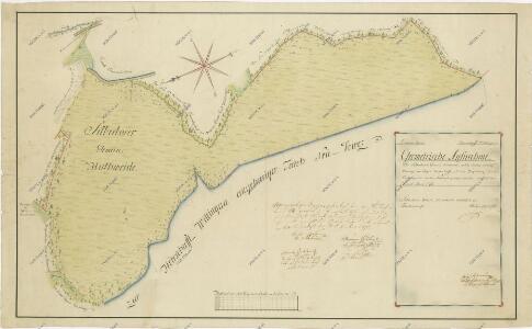
Situační plán kasárenského rybníka na předměstí v Třeboni a jeho okolí
Mapa části povodí Nové Řeky a rybníka Vdovec

Generální mapa panství Třeboň a inkorporovaných statků Bzí, Lomnice, Borovany, Třeboň, Hamr a Val 1

Hollitzky - c1966-1-007 - Kaiserpflichtexemplar der Landkarten des stabilen Katasters
1 : 2880
Hollitzky - c1966-1-013 - Kaiserpflichtexemplar der Landkarten des stabilen Katasters
1 : 2880
Hollitzky - c1966-1-001 - Kaiserpflichtexemplar der Landkarten des stabilen Katasters
1 : 2880
Hollitzky - c1966-1-005 - Kaiserpflichtexemplar der Landkarten des stabilen Katasters
1 : 2880
Hollitzky - c1966-1-008 - Kaiserpflichtexemplar der Landkarten des stabilen Katasters
1 : 2880
Hollitzky - c1966-1-010 - Kaiserpflichtexemplar der Landkarten des stabilen Katasters
1 : 2880
Hollitzky - c1966-1-009 - Kaiserpflichtexemplar der Landkarten des stabilen Katasters
1 : 2880
Hollitzky - c1966-1-006 - Kaiserpflichtexemplar der Landkarten des stabilen Katasters
1 : 2880
Hollitzky - c1966-1-002 - Kaiserpflichtexemplar der Landkarten des stabilen Katasters
1 : 2880
Hollitzky - c1966-1-004 - Kaiserpflichtexemplar der Landkarten des stabilen Katasters
1 : 2880
Hollitzky - c1966-1-012 - Kaiserpflichtexemplar der Landkarten des stabilen Katasters
1 : 2880
Hollitzky - c1966-1-003 - Kaiserpflichtexemplar der Landkarten des stabilen Katasters
1 : 2880
Hollitzky - c1966-1-011 - Kaiserpflichtexemplar der Landkarten des stabilen Katasters
1 : 2880
Porostní mapa polesí Mláka s vyznačením bonity půdy 1
1 : 15000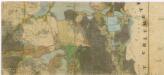
Administrativní mapa třeboňského panství se statky Bzí,Lomnice, Borovany,Hamr a Val 1

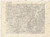
Mapa panství Stráž s hranicemi pantví třeboňského, novobystřického a jindřichohradeckého

Půdní a těžební plán polesí Cep a Zámecký s vyznačením trasy exkurze České lesnické jednoty absolvované v roce 1863 1
[Gradkartenblatt]
1 : 25000 Stráž nad Nežárkou (Česko : oblast) Kartographisches Institut