Maps of Hamr
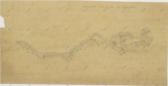
Záměrná mapa - brouilon - povodí Koštěnického potoka od chlumecké železárny k soutoku s Lužnicí
Mapa povodí Zlaté stoky překopírované z katastrálních map přilehlých obcí 1
1 : 2880
Hammerdorf - c1765-1-003 - Kaiserpflichtexemplar der Landkarten des stabilen Katasters
1 : 2880
Hammerdorf - c1765-1-002 - Kaiserpflichtexemplar der Landkarten des stabilen Katasters
1 : 2880
Hammerdorf - c1765-1-001 - Kaiserpflichtexemplar der Landkarten des stabilen Katasters
1 : 2880
Hammerdorf - c1765-1-005 - Kaiserpflichtexemplar der Landkarten des stabilen Katasters
1 : 2880
Hammerdorf - c1765-1-007 - Kaiserpflichtexemplar der Landkarten des stabilen Katasters
1 : 2880
Hammerdorf - c1765-1-006 - Kaiserpflichtexemplar der Landkarten des stabilen Katasters
1 : 2880
Hammerdorf - c1765-1-004 - Kaiserpflichtexemplar der Landkarten des stabilen Katasters
1 : 2880
Chlumetz - c2530-1-001 - Kaiserpflichtexemplar der Landkarten des stabilen Katasters
1 : 2880
Chlumetz - c2530-1-004 - Kaiserpflichtexemplar der Landkarten des stabilen Katasters
1 : 2880
Chlumetz - c2530-1-008 - Kaiserpflichtexemplar der Landkarten des stabilen Katasters
1 : 2880
Chlumetz - c2530-1-003 - Kaiserpflichtexemplar der Landkarten des stabilen Katasters
1 : 2880
Chlumetz - c2530-1-005 - Kaiserpflichtexemplar der Landkarten des stabilen Katasters
1 : 2880
Chlumetz - c2530-1-011 - Kaiserpflichtexemplar der Landkarten des stabilen Katasters
1 : 2880
Chlumetz - c2530-1-009 - Kaiserpflichtexemplar der Landkarten des stabilen Katasters
1 : 2880
Chlumetz - c2530-1-010 - Kaiserpflichtexemplar der Landkarten des stabilen Katasters
1 : 2880
Chlumetz - c2530-1-007 - Kaiserpflichtexemplar der Landkarten des stabilen Katasters
1 : 2880
Chlumetz - c2530-1-002 - Kaiserpflichtexemplar der Landkarten des stabilen Katasters
1 : 2880
Chlumetz - c2530-1-006 - Kaiserpflichtexemplar der Landkarten des stabilen Katasters
1 : 2880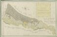
Geometrický plán lesů Vochuzka a u polí Rybákových s přilehlými činžovními pozemky

Hospodářská mapa polesí Cep 1
1 : 5760
Mapy činžovních pozemků III. sekce třeboňského velkostatku pro obce: Branná, Břilice, Domanín, Herda, Holičky, Kojákovice, Spolí, Třeboň 1

Mapy činžovních pozemků III. sekce třeboňského velkostatku pro obce: Branná, Břilice, Domanín, Herda, Holičky, Kojákovice, Spolí 1

Mapy činžovních pozemků III. sekce třeboňského velkostatku pro obce: Břilice, Domanín, Herda, Holičky, Kojákovice, Spolí, Třeboň 1
1 : 2880
Cep o. Jidndřichův Hradec 1
1 : 2880
Mapy činžovních pozemků III. sekce třeboňského velkostatku pro obce: Branná, Břilice, Domanín, Herda, Holičky, Kojákovice, Spolí, Třeboň 1

Cep o. Jindřichův Hradec 1
1 : 2880
Generální mapa panství Třeboň a inkorporovaných statků Bzí, Lomnice, Borovany, Třeboň, Hamr a Val 1