Maps of Drahotěšice

Geometrický plán radonického polesí s připojeným dílem lesa z kosteleckého polesí

Lischnitz - c4143-1-001 - Kaiserpflichtexemplar der Landkarten des stabilen Katasters
1 : 2880
Lischnitz - c4143-1-008 - Kaiserpflichtexemplar der Landkarten des stabilen Katasters
1 : 2880
Lischnitz - c4143-1-004 - Kaiserpflichtexemplar der Landkarten des stabilen Katasters
1 : 2880
Lischnitz - c4143-1-010 - Kaiserpflichtexemplar der Landkarten des stabilen Katasters
1 : 2880
Lischnitz - c4143-1-005 - Kaiserpflichtexemplar der Landkarten des stabilen Katasters
1 : 2880
Lischnitz - c4143-1-003 - Kaiserpflichtexemplar der Landkarten des stabilen Katasters
1 : 2880
Lischnitz - c4143-1-002 - Kaiserpflichtexemplar der Landkarten des stabilen Katasters
1 : 2880
Lischnitz - c4143-1-007 - Kaiserpflichtexemplar der Landkarten des stabilen Katasters
1 : 2880
Lischnitz - c4143-1-006 - Kaiserpflichtexemplar der Landkarten des stabilen Katasters
1 : 2880
Lischnitz - c4143-1-009 - Kaiserpflichtexemplar der Landkarten des stabilen Katasters
1 : 2880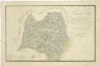
Geometrický plán hlubockého lesa Spálený, jehož část byla směnou připojena k panství Třeboň 1
Líšnice o. České Budějovice 1
1 : 2880
Líšnice o. České Budějovice 1
1 : 2880
Líšnice o. České Budějovice 1
1 : 2880
Líšnice o. České Budějovice 1
1 : 2880
Líšnice o. České Budějovice 1
1 : 2880
Líšnice o. České Budějovice 1
1 : 2880
Líšnice o. České Budějovice 1
1 : 2880
Líšnice o. České Budějovice 1
1 : 2880
Drahotěšice o. České Budějovice 1
1 : 2880
Mapy činžovních pozemků I. sekce třeboňského velkostatku pro obce: Borkovice, Bošilec, Drahotěšice, Frahelž, Hamr, Horusice, Lhota, Líšnice, Mažice, Mezimostí, Ponědraž, Ponědrážka, Řípec, Val, Vlkov 1
1 : 2880
Mapy činžovních pozemků sekce Bzí pro obce: Štipoklasy, Tuchovice a Dobšice 1
1 : 2880
Mapy činžovních pozemků I. sekce třeboňského velkostatku pro obce: Borkovice, Bošilec, Drahotěšice, Frahelž, Hamr, Horusice, Lhota, Líšnice, Mažice, Mezimostí, Ponědraž, Ponědrážka, Řípec, Val, Vlkov 1
1 : 2880
Líšnice o. České Budějovice 1
1 : 2880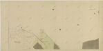
Líšnice o. České Budějovice 1
1 : 2880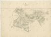
Přehledná mapa polesí Radonice 1

Generální mapa panství Třeboň a inkorporovaných statků Bzí, Lomnice, Borovany, Třeboň, Hamr a Val 1

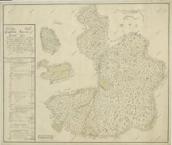
Porostní mapa polesí Poněšice 1

Drahotieschitz - c1499-1-004 - Kaiserpflichtexemplar der Landkarten des stabilen Katasters
1 : 2880
Drahotieschitz - c1499-1-003 - Kaiserpflichtexemplar der Landkarten des stabilen Katasters
1 : 2880
Drahotieschitz - c1499-1-002 - Kaiserpflichtexemplar der Landkarten des stabilen Katasters
1 : 2880
Drahotieschitz - c1499-1-005 - Kaiserpflichtexemplar der Landkarten des stabilen Katasters
1 : 2880
Drahotieschitz - c1499-1-006 - Kaiserpflichtexemplar der Landkarten des stabilen Katasters
1 : 2880