Maps of Oslov

Pantografická zmenšenina originálního měření lesů obce Oslova 1
1 : 8640
Mapa dvora Oslova 1
1 : 1440
Mapa dvora Oslova 1
Oslov se sv. Annou a částí Červené, okr. Písek, list 13 1
Oslov se sv. Annou a částí Červené, okr. Písek, list 4 1

Stereofotogrammetrické zaměření... Vltavy, Otavy... pomocí Zeissova fototeodolitu
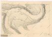
Geometrický nárys panského lesa Pod kopaninou , sporného s poddaným Staňkem z Červené 1

Stereofotogrammetrické zaměření... Vltavy, Otavy... pomocí Zeissova fototeodolitu
Kučeř, okr. Písek, list 8 1
Stereofotogrammetrické zaměření... Vltavy, Otavy... pomocí Zeissova fototeodolitu

Zbonín se Štědronínem a Plazy, okr. Písek, list 1 list 1
1 : 2880
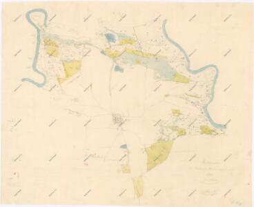
Woslow - c5540-1-009 - Kaiserpflichtexemplar der Landkarten des stabilen Katasters
1 : 2880
Woslow - c5540-1-005 - Kaiserpflichtexemplar der Landkarten des stabilen Katasters
1 : 2880
Woslow - c5540-1-006 - Kaiserpflichtexemplar der Landkarten des stabilen Katasters
1 : 2880
Woslow - c5540-1-003 - Kaiserpflichtexemplar der Landkarten des stabilen Katasters
1 : 2880
Woslow - c5540-1-007 - Kaiserpflichtexemplar der Landkarten des stabilen Katasters
1 : 2880
Woslow - c5540-1-002 - Kaiserpflichtexemplar der Landkarten des stabilen Katasters
1 : 2880
Woslow - c5540-1-004 - Kaiserpflichtexemplar der Landkarten des stabilen Katasters
1 : 2880
Woslow - c5540-1-008 - Kaiserpflichtexemplar der Landkarten des stabilen Katasters
1 : 2880
Woslow - c5540-1-001 - Kaiserpflichtexemplar der Landkarten des stabilen Katasters
1 : 2880
Přehledná mapa panství Orlíka a přivtělených statků Bukovan, Zalužan a Zbenic, list 48 1

První zařizovací elaborát orlických lesů od Ing. Frant. Josefa Matze vyhotovený před r. 1791, Revír Spole, list 7 1

Diedowitz (Dědowic) - c1101-1-004 - Kaiserpflichtexemplar der Landkarten des stabilen Katasters
1 : 2880
Diedowitz (Dědowic) - c1101-1-002 - Kaiserpflichtexemplar der Landkarten des stabilen Katasters
1 : 2880
Diedowitz (Dědowic) - c1101-1-001 - Kaiserpflichtexemplar der Landkarten des stabilen Katasters
1 : 2880
Diedowitz (Dědowic) - c1101-1-005 - Kaiserpflichtexemplar der Landkarten des stabilen Katasters
1 : 2880
Diedowitz (Dědowic) - c1101-1-003 - Kaiserpflichtexemplar der Landkarten des stabilen Katasters
1 : 2880
Diedowitz (Dědowic) - c1101-1-006 - Kaiserpflichtexemplar der Landkarten des stabilen Katasters
1 : 2880
Tuklek - c8107-1-001 - Kaiserpflichtexemplar der Landkarten des stabilen Katasters
1 : 2880
Tuklek - c8107-1-002 - Kaiserpflichtexemplar der Landkarten des stabilen Katasters
1 : 2880