Maps of Libníč

Přehledná mapa dolů v okolí Libníč a Jelmo 1

Libnitsch - c4028-1-001 - Kaiserpflichtexemplar der Landkarten des stabilen Katasters
1 : 2880
Libnitsch - c4028-1-003 - Kaiserpflichtexemplar der Landkarten des stabilen Katasters
1 : 2880
Libnitsch - c4028-1-004 - Kaiserpflichtexemplar der Landkarten des stabilen Katasters
1 : 2880
Libnitsch - c4028-1-002 - Kaiserpflichtexemplar der Landkarten des stabilen Katasters
1 : 2880
Záměrná mapa hranic lesů a pozemků v okolí městečka Lišov 1

[Gradkartenblatt]
1 : 25000 Hluboká nad Vltavou-oblast (Česko) Vojenský zeměpisný ústav

III. vojenské mapování 4353/3
1 : 25000
Gradkartenblatt
1 : 25000 Hluboká nad Vltavou-oblast (Česko) Czöppan, Johann
Umgebung von Budweis
1 : 37000 České Budějovice-oblast (Česko) Popper, Filipp L.E. Hansen
Topographische Karte ... Herrschaft Krummau ...

Topographische Karte der in Böhmen budweiser Kreises liegenden

Podrobné mapy zemí Koruny české v měřítku 1:75.000 a mapa vzdáleností všech míst při silnici ležících - Veselí - Lomnice - Hluboká. Průvodce statisticko-historický po všech místech na těchto mapách uvedených a rejstřík věcný názvů hor, potoků, řek, rybníků atd. Sešit 27. List 60,
1 : 75000
Uibersichts-Karte der hochfürstlich zu Schwarzenbergschen Domaine Frauenberg nach dem Stande im Jahre 1876
1 : 58000 Hluboká nad Vltavou-oblast (Česko) Danesch, Jos. Kreibich, František Jakub Jindřich
České Budějovice a okolí
1 : 75000 České Budějovice (Česko : oblast) Vojenský zeměpisný ústav
III. vojenské mapování 4353
1 : 75000
Wittingau und Moldauthein
1 : 75000 Týn nad Vltavou (Česko : oblast) Pflügl K. u. k. militär-geographisches Institut
Wittingau und Moldauthein
1 : 75000 Týn nad Vltavou (Česko : oblast) Pflügl K. u. k. Militärgeographisches Institut
Wittingau und Moldauthein
1 : 75000 Třeboň (Česko : oblast) K. u. k. Militärgeographisches Institut
Třeboň
1 : 75000 Třeboň (Česko : oblast) Reichsamt für Landesaufnahme
Třeboň
1 : 75000 Třeboň-oblast (Česko) Vojenský zeměpisný ústav
Administrativ Karte der Hochfürstlich Schwarzenberg ́schen Herrschaft Frauenberg...
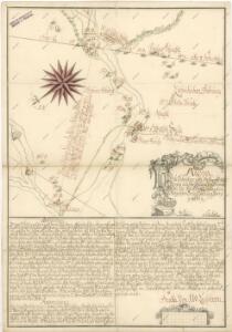
Plan der k.k. Chaussée und der im Bau bergriffenen Eisenbahn von Budweis bis zum Scheidungspunkte bei Leopoldschlag
1 : 73500 České Budějovice-Linec (železniční trať) Pilarski, V. Casimir Frühwirt, E. K. in der Kunsthandlung des H.F. Müller
Vltava

Administrativ Karte der Hochfürstlich Schwarzenberg'schen Herrschaften Wittingau
1 : 57600 Třeboň-oblast (Česko) Stifter, Johann Falta, Josef Bzy und Forbes
Vodní stavby zřízené v 15. a 16. století na Třeboňsku

Administrativní mapa třeboňského panství se statky Bzí a Borovany 1

Administrativní mapa třeboňského panství se statky Bzí a Borovany 1