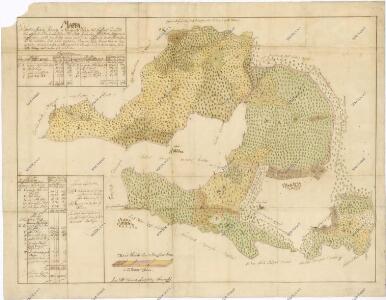
Maps of Hosín

Přehledná mapa tzv. rezervovaných lesů ležících na panství Hluboká nad Vltavou. Připojena tabulka s popisy a výměrami 1

Geometrický plán lesů u Líšnice s přilehlými činžovními a propachtovanými pozemky 1

Geometrický plán lesů u Líšnice s přilehlými činžovními a propachtovanými pozemky 1

Geometrický plán lesů u Líšnice s přilehlými činžovními a propachtovanými pozemky 1
Líšnice o. České Budějovice 1
1 : 2880
Líšnice o. České Budějovice 1
1 : 2880
Dobrzegitz - c1204-1-008 - Kaiserpflichtexemplar der Landkarten des stabilen Katasters
1 : 2880
Dobrzegitz - c1204-1-012 - Kaiserpflichtexemplar der Landkarten des stabilen Katasters
1 : 2880
Dobrzegitz - c1204-1-010 - Kaiserpflichtexemplar der Landkarten des stabilen Katasters
1 : 2880
Dobrzegitz - c1204-1-017 - Kaiserpflichtexemplar der Landkarten des stabilen Katasters
1 : 2880
Dobrzegitz - c1204-1-001 - Kaiserpflichtexemplar der Landkarten des stabilen Katasters
1 : 2880
Dobrzegitz - c1204-1-009 - Kaiserpflichtexemplar der Landkarten des stabilen Katasters
1 : 2880
Dobrzegitz - c1204-1-018 - Kaiserpflichtexemplar der Landkarten des stabilen Katasters
1 : 2880
Dobrzegitz - c1204-1-016 - Kaiserpflichtexemplar der Landkarten des stabilen Katasters
1 : 2880
Dobrzegitz - c1204-1-013 - Kaiserpflichtexemplar der Landkarten des stabilen Katasters
1 : 2880
Dobrzegitz - c1204-1-014 - Kaiserpflichtexemplar der Landkarten des stabilen Katasters
1 : 2880
Dobrzegitz - c1204-1-011 - Kaiserpflichtexemplar der Landkarten des stabilen Katasters
1 : 2880
Dobrzegitz - c1204-1-007 - Kaiserpflichtexemplar der Landkarten des stabilen Katasters
1 : 2880
Dobrzegitz - c1204-1-004 - Kaiserpflichtexemplar der Landkarten des stabilen Katasters
1 : 2880
Dobrzegitz - c1204-1-015 - Kaiserpflichtexemplar der Landkarten des stabilen Katasters
1 : 2880
Dobrzegitz - c1204-1-002 - Kaiserpflichtexemplar der Landkarten des stabilen Katasters
1 : 2880
Dobrzegitz - c1204-1-006 - Kaiserpflichtexemplar der Landkarten des stabilen Katasters
1 : 2880
Dobrzegitz - c1204-1-003 - Kaiserpflichtexemplar der Landkarten des stabilen Katasters
1 : 2880
Dobrzegitz - c1204-1-005 - Kaiserpflichtexemplar der Landkarten des stabilen Katasters
1 : 2880
Generální mapa panství Třeboň a inkorporovaných statků Bzí, Lomnice, Borovany, Třeboň, Hamr a Val 1

Wittin - c8627-1-004 - Kaiserpflichtexemplar der Landkarten des stabilen Katasters
1 : 2880
Wittin - c8627-1-001 - Kaiserpflichtexemplar der Landkarten des stabilen Katasters
1 : 2880
Wittin - c8627-1-005 - Kaiserpflichtexemplar der Landkarten des stabilen Katasters
1 : 2880
Wittin - c8627-1-002 - Kaiserpflichtexemplar der Landkarten des stabilen Katasters
1 : 2880