Maps of Oslov

Mapa dvora Oslova 1
1 : 1440
Mapa dvora Oslova 1
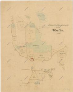
Oslov se sv. Annou a částí Červené, okr. Písek, list 4 1

Pantografická zmenšenina originálního měření lesů obce Oslova 1
1 : 8640
Woslow - c5540-1-009 - Kaiserpflichtexemplar der Landkarten des stabilen Katasters
1 : 2880
Woslow - c5540-1-005 - Kaiserpflichtexemplar der Landkarten des stabilen Katasters
1 : 2880
Woslow - c5540-1-006 - Kaiserpflichtexemplar der Landkarten des stabilen Katasters
1 : 2880
Woslow - c5540-1-003 - Kaiserpflichtexemplar der Landkarten des stabilen Katasters
1 : 2880
Woslow - c5540-1-007 - Kaiserpflichtexemplar der Landkarten des stabilen Katasters
1 : 2880
Woslow - c5540-1-002 - Kaiserpflichtexemplar der Landkarten des stabilen Katasters
1 : 2880
Woslow - c5540-1-004 - Kaiserpflichtexemplar der Landkarten des stabilen Katasters
1 : 2880
Woslow - c5540-1-008 - Kaiserpflichtexemplar der Landkarten des stabilen Katasters
1 : 2880
Woslow - c5540-1-001 - Kaiserpflichtexemplar der Landkarten des stabilen Katasters
1 : 2880
Přehledná mapa velkostatku Orlíka, Čimelic, Varvažova, Tochovic a přivtělených statků Bukovan, Zalužan a Zbenic podle majetkového stavu z r. 1913, list 12 1
1 : 25000
První zařizovací elaborát orlických lesů od Ing. Frant. Josefa Matze vyhotovený před r. 1791, Revír Spole, list 7 1

Přehledná mapa panství Orlíka a přivtělených statků Bukovan, Zalužan a Zbenic, list 48 1
Oslov se sv. Annou a částí Červené, okr. Písek, list 13 1

Tuklek - c8107-1-001 - Kaiserpflichtexemplar der Landkarten des stabilen Katasters
1 : 2880
Tuklek - c8107-1-002 - Kaiserpflichtexemplar der Landkarten des stabilen Katasters
1 : 2880
Tuklek - c8107-1-003 - Kaiserpflichtexemplar der Landkarten des stabilen Katasters
1 : 2880
Stereofotogrammetrické zaměření... Vltavy, Otavy... pomocí Zeissova fototeodolitu

III. vojenské mapování 4252/2
1 : 25000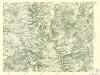
III. vojenské mapování 4252/2
1 : 25000
Gradkartenblatt
1 : 25000 Zvíkovské Podhradí-oblast (Česko) Albrecht, Julius
Přehledná mapa obrysová velkostatku Orlíka, Čimelic, Varvažova, Tochovic a přivtělených statků Bukovan, Zalužan a Zbenic se začatým vybarvováním majetkového stavu k r. 1903/04, nedokončená, list 2 1
1 : 25000
Bestandskarte und Hiebsplan für die Excursionstour des böhm. Forstvereins im August 1890 auf der Herrschaft Worlik
Orlík nad Vltavou-oblast (Česko) Waraus, E. Meinhard, Carl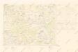
Mapy plánování ČSR


Přehledná mapa velkostatku Orlíka, Čimelic, Varvažova, Tochovic a přivtělených statků Bukovan, Zalužan, a Zbenic podle majetkového stavu z r. 1905/06 1
1 : 25000