Maps of Štěpánovice

Situační plány vrchnostenských objektů na velkostatku Třeboň 1
1 : 2880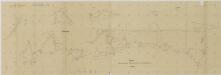
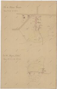
Manuály parcelace pozemků dvora Vranín 1
1 : 2880
Štěpánovice o. České Budějovice 1
1 : 2880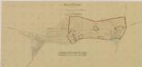
Mapa dělení pozemků dvora Vranín po I. pozemkové reformě, s vyznačením bonity půdy 1
1 : 5760
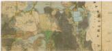
Hospodářská mapa polesí Štěpánovice 1

Hospodářská mapa polesí Štěpánovice 1
1 : 5760
Břilice o. Jindřichův Hradec 1
1 : 2880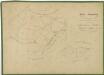
Hospodářská mapa polesí Štěpánovice 1

Stiepanowitz - c7778-1-008 - Kaiserpflichtexemplar der Landkarten des stabilen Katasters
1 : 2880
Stiepanowitz - c7778-1-007 - Kaiserpflichtexemplar der Landkarten des stabilen Katasters
1 : 2880
Stiepanowitz - c7778-1-002 - Kaiserpflichtexemplar der Landkarten des stabilen Katasters
1 : 2880
Stiepanowitz - c7778-1-005 - Kaiserpflichtexemplar der Landkarten des stabilen Katasters
1 : 2880
Stiepanowitz - c7778-1-004 - Kaiserpflichtexemplar der Landkarten des stabilen Katasters
1 : 2880
Stiepanowitz - c7778-1-003 - Kaiserpflichtexemplar der Landkarten des stabilen Katasters
1 : 2880
Stiepanowitz - c7778-1-006 - Kaiserpflichtexemplar der Landkarten des stabilen Katasters
1 : 2880
Stiepanowitz - c7778-1-001 - Kaiserpflichtexemplar der Landkarten des stabilen Katasters
1 : 2880
Štěpánovice o. České Budějovice 1
1 : 2880
Porostní mapa polesí Štěpánovice 1
1 : 10000
Brzillitz - c0612-1-003 - Kaiserpflichtexemplar der Landkarten des stabilen Katasters
1 : 2880
Brzillitz - c0612-1-002 - Kaiserpflichtexemplar der Landkarten des stabilen Katasters
1 : 2880
Brzillitz - c0612-1-004 - Kaiserpflichtexemplar der Landkarten des stabilen Katasters
1 : 2880
Brzillitz - c0612-1-008 - Kaiserpflichtexemplar der Landkarten des stabilen Katasters
1 : 2880
Brzillitz - c0612-1-006 - Kaiserpflichtexemplar der Landkarten des stabilen Katasters
1 : 2880
Brzillitz - c0612-1-001 - Kaiserpflichtexemplar der Landkarten des stabilen Katasters
1 : 2880
Brzillitz - c0612-1-007 - Kaiserpflichtexemplar der Landkarten des stabilen Katasters
1 : 2880
Brzillitz - c0612-1-005 - Kaiserpflichtexemplar der Landkarten des stabilen Katasters
1 : 2880
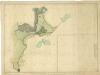
Generální mapa panství Třeboň a inkorporovaných statků Bzí, Lomnice, Borovany, Třeboň, Hamr a Val 1
Administrativní mapa třeboňského panství se statky Bzí,Lomnice, Borovany,Hamr a Val 1

Situační plán erární silnice od dvora Kuna do Ledenic 1