Maps of Hošťka

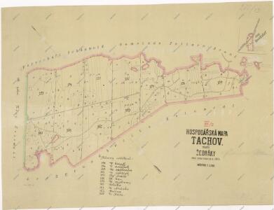
Hospodářská mapa polesí Žebráky
1 : 5760
Porostní mapa revíru Žebráky
1 : 11520
Přehledová mapa velkostatku Tachov
1 : 5747
Neuhäusl - c5260-1-002 - Kaiserpflichtexemplar der Landkarten des stabilen Katasters
1 : 2880
Neuhäusl - c5260-1-001 - Kaiserpflichtexemplar der Landkarten des stabilen Katasters
1 : 2880
Neuhäusl - c5260-1-004 - Kaiserpflichtexemplar der Landkarten des stabilen Katasters
1 : 2880
Neuhäusl - c5260-1-005 - Kaiserpflichtexemplar der Landkarten des stabilen Katasters
1 : 2880
Neuhäusl - c5260-1-003 - Kaiserpflichtexemplar der Landkarten des stabilen Katasters
1 : 2880
Mapa obce Žebráckého Zďáru
1 : 2603
Katastrální mapa obce Žebráky
1 : 2880
Katastrální mapa obce Žebráky
1 : 2880
Katastrální mapa obce Nový Losimtál ZS-XVI-21 bf
1 : 2880
Petlarn - c9379-1-006 - Kaiserpflichtexemplar der Landkarten des stabilen Katasters
1 : 2880
Petlarn - c9379-1-002 - Kaiserpflichtexemplar der Landkarten des stabilen Katasters
1 : 2880
Petlarn - c9379-1-007 - Kaiserpflichtexemplar der Landkarten des stabilen Katasters
1 : 2880
Petlarn - c9379-1-005 - Kaiserpflichtexemplar der Landkarten des stabilen Katasters
1 : 2880
Petlarn - c9379-1-001 - Kaiserpflichtexemplar der Landkarten des stabilen Katasters
1 : 2880
Petlarn - c9379-1-004 - Kaiserpflichtexemplar der Landkarten des stabilen Katasters
1 : 2880
Petlarn - c9379-1-003 - Kaiserpflichtexemplar der Landkarten des stabilen Katasters
1 : 2880
Katastrální mapa obce Žebráky
1 : 2880
Hospodářská mapa revíru Jedlina II. sekce
1 : 5760
Katastrální mapa obce Nový Losimtál (Jedlina) WC-XVI-21 be
1 : 2880
Katastrální mapa obce Nový Losimtál ZS-XVI-21 be
1 : 2880
III. vojenské mapování 4149/1
1 : 25000
Gradkartenblatt
1 : 25000 Rozvadov-oblast (Česko) Bulla, Eduard
Přehledová mapa revírů Horní Výšina, Jalový Dvůr, Obora, Milíře, Pavlův Studenec, Zlatý Potok, Nový Losimtál
1 : 22942
Generalkarte der sämtlichen obrigkeitlichen Herrschaft Mayerhöfer Waldungen
Rozvadov-oblast (Česko) Biedermann, Kurt Walter, Maxmilian
Porostní mapa revíru Jedlina
1 : 11520
Neulosymthal - c2806-3-005 - Kaiserpflichtexemplar der Landkarten des stabilen Katasters
1 : 2880
Neulosymthal - c2806-3-004 - Kaiserpflichtexemplar der Landkarten des stabilen Katasters
1 : 2880
Neulosymthal - c2806-3-006 - Kaiserpflichtexemplar der Landkarten des stabilen Katasters
1 : 2880
Neulosymthal - c2806-3-001 - Kaiserpflichtexemplar der Landkarten des stabilen Katasters
1 : 2880
Neulosymthal - c2806-3-007 - Kaiserpflichtexemplar der Landkarten des stabilen Katasters
1 : 2880
Neulosymthal - c2806-3-002 - Kaiserpflichtexemplar der Landkarten des stabilen Katasters
1 : 2880