Maps of Tisová

Porostní mapa lesního hospodářského celku Svatá-Studánka-Trnová
1 : 11520
Hospodářská mapa revíru Tachov-Trnová
1 : 5760
Porostní mapa revíru Trnová
1 : 11520
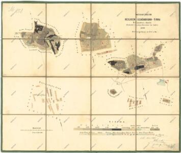
Přehledová mapa velkostatku Tachov
1 : 5747
Katastrální mapa obce Tisová s osadou Trnová
1 : 2880
Katastrální mapa obce Kumpolec
1 : 2880
Katastrální mapa obce Tisová s osadou Trnová
1 : 2880
Parcelní plán dvora Pernolec
1 : 2632
Záměrná mapa pozemků a rybníků dvora Pernolec
1 : 5760
Situační plán pro hon v Trnové
1 : 25857
Přehledová mapa dvorů Tisová a Trnová
1 : 6011
Tissa - c7919-1-003 - Kaiserpflichtexemplar der Landkarten des stabilen Katasters
1 : 2880
Tissa - c7919-1-002 - Kaiserpflichtexemplar der Landkarten des stabilen Katasters
1 : 2880
Tissa - c7919-1-001 - Kaiserpflichtexemplar der Landkarten des stabilen Katasters
1 : 2880
Tissa - c7919-1-005 - Kaiserpflichtexemplar der Landkarten des stabilen Katasters
1 : 2880
Tissa - c7919-1-004 - Kaiserpflichtexemplar der Landkarten des stabilen Katasters
1 : 2880
Ulliersreith - c5417-1-002 - Kaiserpflichtexemplar der Landkarten des stabilen Katasters
1 : 2880
Ulliersreith - c5417-1-003 - Kaiserpflichtexemplar der Landkarten des stabilen Katasters
1 : 2880
Ulliersreith - c5417-1-004 - Kaiserpflichtexemplar der Landkarten des stabilen Katasters
1 : 2880
Ulliersreith - c5417-1-001 - Kaiserpflichtexemplar der Landkarten des stabilen Katasters
1 : 2880
Gumplitz (Gumplice) - c3692-1-001 - Kaiserpflichtexemplar der Landkarten des stabilen Katasters
1 : 2880
Gumplitz (Gumplice) - c3692-1-002 - Kaiserpflichtexemplar der Landkarten des stabilen Katasters
1 : 2880
Gumplitz (Gumplice) - c3692-1-004 - Kaiserpflichtexemplar der Landkarten des stabilen Katasters
1 : 2880
Gumplitz (Gumplice) - c3692-1-003 - Kaiserpflichtexemplar der Landkarten des stabilen Katasters
1 : 2880
Katastrální mapa obce Tisová s osadou Trnová
1 : 2880
Přehledová mapa velkostatku Tachov
1 : 17280
Hospodářská mapa revíru Kočov
1 : 11520
Schossenreith - c0799-1-002 - Kaiserpflichtexemplar der Landkarten des stabilen Katasters
1 : 2880
Schossenreith - c0799-1-004 - Kaiserpflichtexemplar der Landkarten des stabilen Katasters
1 : 2880
Schossenreith - c0799-1-003 - Kaiserpflichtexemplar der Landkarten des stabilen Katasters
1 : 2880