Maps of Obora

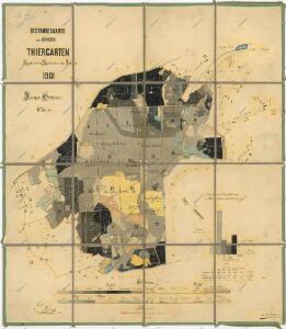
Porostní mapa revíru Obora
1 : 11520
Tiergarten - c5353-1-001 - Kaiserpflichtexemplar der Landkarten des stabilen Katasters
1 : 2880
Tiergarten - c5353-1-006 - Kaiserpflichtexemplar der Landkarten des stabilen Katasters
1 : 2880
Tiergarten - c5353-1-004 - Kaiserpflichtexemplar der Landkarten des stabilen Katasters
1 : 2880
Tiergarten - c5353-1-005 - Kaiserpflichtexemplar der Landkarten des stabilen Katasters
1 : 2880
Tiergarten - c5353-1-002 - Kaiserpflichtexemplar der Landkarten des stabilen Katasters
1 : 2880
Tiergarten - c5353-1-003 - Kaiserpflichtexemplar der Landkarten des stabilen Katasters
1 : 2880
Záměrná mapa parcel obce Obora
1 : 2880
Katastrální mapa obce Branka WC-XVI-19 ci
1 : 2880
Katastrální mapa obce Obora
1 : 2880
Katastrální mapa obce Pavlův Studenec WC-XVI-19 di
1 : 2880
Katastrální mapa obce Lučina WC-XVI-19 ai
1 : 2880
Katastrální mapa obce Milíře
1 : 2880
Sorghof - c4288-2-003 - Kaiserpflichtexemplar der Landkarten des stabilen Katasters
1 : 2880
Sorghof - c4288-2-004 - Kaiserpflichtexemplar der Landkarten des stabilen Katasters
1 : 2880
Sorghof - c4288-2-005 - Kaiserpflichtexemplar der Landkarten des stabilen Katasters
1 : 2880
Sorghof - c4288-2-002 - Kaiserpflichtexemplar der Landkarten des stabilen Katasters
1 : 2880
Sorghof - c4288-2-001 - Kaiserpflichtexemplar der Landkarten des stabilen Katasters
1 : 2880
Katastrální mapa obce Obora
1 : 2880
Porostní mapa revíru Jalový Dvůr (Branka) a Horní Výšina
1 : 11520
Porostní mapa revíru Obora
1 : 11520
Porostní mapa revíru Jalový Dvůr (Branka)
1 : 11520
Porostní mapa revíru Obora
1 : 11671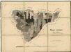
Porostní mapa revíru Jalový Dvůr (Branka)
1 : 11523
Porostní mapa revíru Jalový Dvůr (Branka)
1 : 11520
Katastrální mapa obce Pavlův Studenec WC-XVII-20 ah
1 : 2880
Porostní mapa revíru Jalový Dvůr (Branka)
1 : 11520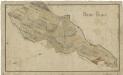
Mapa revíru Milíře
1 : 11257
Mapa vrchnostenských pozemků u obce Jalový Dvůr (Branka)
1 : 2784
Galtenhof - c0469-2-002 - Kaiserpflichtexemplar der Landkarten des stabilen Katasters
1 : 2880
Galtenhof - c0469-2-004 - Kaiserpflichtexemplar der Landkarten des stabilen Katasters
1 : 2880
Galtenhof - c0469-2-005 - Kaiserpflichtexemplar der Landkarten des stabilen Katasters
1 : 2880
Galtenhof - c0469-2-001 - Kaiserpflichtexemplar der Landkarten des stabilen Katasters
1 : 2880